La Luz geodata
La Luz (Barinas) is a seat of a third-order administrative division; located in Venezuela in America/Caracas (GMT-4) time zone. In our database, there are 108 cities with bigger population. Compared to other cities in Venezuela, 76.8% of cities are located further ↑North; 62.8% of cities are located further →East and 62.6% of cities have higher elevation than La Luz. Note1


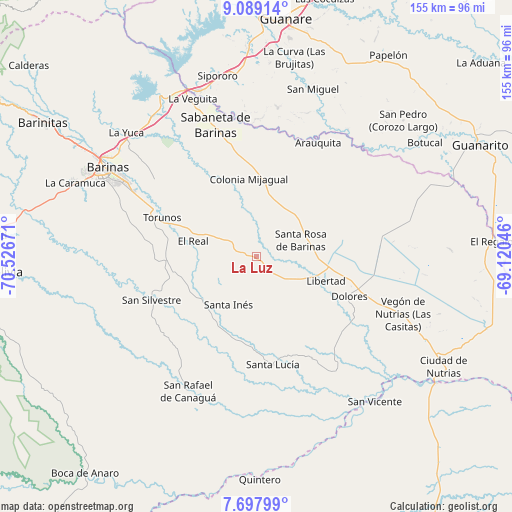
La Luz GPS coordinates[2]
8° 23' 39.084" North, 69° 49' 24.888" West
| Map corner | latitude | longitude |
|---|---|---|
| Upper-left | 9.08914°, | -70.52671° |
| Center: | 8.39419°, | -69.82358° |
| Lower-right: | 7.69799°, | -69.12046° |
| Map W x H: | 154.7×154.7 km | = 96.1×96.1mi |
| max Lat: | 11.94788° ⇑76.8% North |
| La Luz: | 8.39419° |
| min Lat: | ⇓23.2% South 1.92027° |
| min Long | La Luz | max Long |
| -72.55212° | -69.82358° | -60.99778° |
| W 37.2%⇐ | ⇒62.8% E |
Elevation
Elevation of La Luz is 119 m = 390 ft, and this is 261.6 m = 858 ft below average elevation for this country.
| Max E: |
2986 m = 9797 ft | 62.6% |
| Avg. | 380.6 m = 1249 ft | |
| La Luz | 119 m = 390 ft | |
Min E: |
-4 m = -13 ft | 37.4% |
See also: Venezuela elevation on elevation.city.
Geographical zone
La Luz is located in North Torrid zone (between Equator and Tropic of Cancer). Distance of Equator is 933.3 km =579.9 mi to South.| Distance of | km | miles | from La Luz |
|---|---|---|---|
| North Pole | 9073.7 | 5638.1 | to North |
| Arctic Circle | 6467.8 | 4018.9 | to North |
| Tropic Cancer | 1672.6 | 1039.3 | to North |
| Equator | 933.3 | 579.9 | to South |


Nearby cities:
15 places around La Luz: (largest is in red/bold)
• Alto Barinas
49.5 km =30.8 mi,  296°
296°
• Arauquita
39.4 km =24.5 mi,  27°
27°
• Barinas
49.3 km =30.6 mi, 301°
• Dolores
30.7 km =19.1 mi,  112°
112°
• El Real
19.5 km =12.1 mi,  283°
283°
• Las Casitas del Vegon de Nutrias
47.9 km =29.8 mi, 111°
• Libertad
22.5 km =14 mi, 109°
• Obispos
38.9 km =24.2 mi,  307°
307°
• Sabaneta
41.6 km =25.8 mi,  343°
343°
• San Rafael de Canaguá
45.7 km =28.4 mi,  206°
206°
• San Silvestre
34.2 km =21.3 mi,  247°
247°
• Santa Inés
16.8 km =10.4 mi, 209°
• Santa Lucía
32.9 km =20.4 mi,  171°
171°
• Santa Rosa
14.4 km =8.9 mi,  69°
69°
• Torunos
30.6 km =19 mi,  292°
292°
Sources, notices
• [Note1] Compared only with cities in Venezuela existing in our database
• [Src1] Map data: © OpenStreetMap contributors (CC-BY-SA)
• [Src2] Other city data from geonames.org with taken over terms of usage.
• [Src3] Geographical zone / Annual Mean Temperature by Robert A. Rohde @ Wikipedia
