Dolores geodata
Dolores (Barinas) is a seat of a third-order administrative division; located in Venezuela in America/Caracas (GMT-4) time zone. In our database, there are 108 cities with bigger population. Compared to other cities in Venezuela, 79.1% of cities are located further ↑North; 59.3% of cities are located further →East and 65.9% of cities have higher elevation than Dolores. Note1


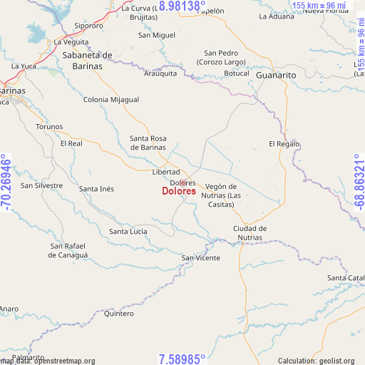
Dolores GPS coordinates[2]
8° 17' 10.428" North, 69° 33' 58.788" West
| Map corner | latitude | longitude |
|---|---|---|
| Upper-left | 8.98138°, | -70.26946° |
| Center: | 8.28623°, | -69.56633° |
| Lower-right: | 7.58985°, | -68.86321° |
| Map W x H: | 154.7×154.7 km | = 96.1×96.1mi |
| max Lat: | 11.94788° ⇑79.1% North |
| Dolores: | 8.28623° |
| min Lat: | ⇓20.9% South 1.92027° |
| min Long | Dolores | max Long |
| -72.55212° | -69.56633° | -60.99778° |
| W 40.7%⇐ | ⇒59.3% E |
Elevation
Elevation of Dolores is 100 m = 328 ft, and this is 280.6 m = 921 ft below average elevation for this country.
| Max E: |
2986 m = 9797 ft | 65.9% |
| Avg. | 380.6 m = 1249 ft | |
| Dolores | 100 m = 328 ft | |
Min E: |
-4 m = -13 ft | 34.1% |
See also: Venezuela elevation on elevation.city.
Geographical zone
Dolores is located in North Torrid zone (between Equator and Tropic of Cancer). Distance of Equator is 921.3 km =572.5 mi to South.| Distance of | km | miles | from Dolores |
|---|---|---|---|
| North Pole | 9085.7 | 5645.6 | to North |
| Arctic Circle | 6479.8 | 4026.4 | to North |
| Tropic Cancer | 1684.6 | 1046.8 | to North |
| Equator | 921.3 | 572.5 | to South |


Nearby cities:
15 places around Dolores: (largest is in red/bold)
• Arauquita
48 km =29.8 mi,  347°
347°
• Bruzual
36.7 km =22.8 mi,  135°
135°
• Ciudad De Nutrias
35.5 km =22.1 mi,  126°
126°
• El Real
50.1 km =31.1 mi,  289°
289°
• El Regalo
45.9 km =28.5 mi,  68°
68°
• Guanarito
60.2 km =37.4 mi,  40°
40°
• La Luz
30.7 km =19.1 mi, 292°
• Las Casitas del Vegon de Nutrias
17.2 km =10.7 mi,  108°
108°
• Libertad
8.4 km =5.2 mi,  302°
302°
• Puerto de Nutrias
37.5 km =23.3 mi, 129°
• San Rafael de Canaguá
56.6 km =35.2 mi,  239°
239°
• San Silvestre
59.9 km =37.2 mi,  268°
268°
• Santa Inés
36.6 km =22.7 mi, 265°
• Santa Lucía
31 km =19.3 mi,  228°
228°
• Santa Rosa
22.7 km =14.1 mi,  319°
319°
Sources, notices
• [Note1] Compared only with cities in Venezuela existing in our database
• [Src1] Map data: © OpenStreetMap contributors (CC-BY-SA)
• [Src2] Other city data from geonames.org with taken over terms of usage.
• [Src3] Geographical zone / Annual Mean Temperature by Robert A. Rohde @ Wikipedia
