Yumare geodata
Yumare (Yaracuy) is a seat of a second-order administrative division; located in Venezuela in America/Caracas (GMT-4) time zone. In our database, there are 108 cities with bigger population. Compared to other cities in Venezuela, 87% of cities are located further ↓South; 51.9% of cities are located further ←West and 75.3% of cities have higher elevation than Yumare. Note1


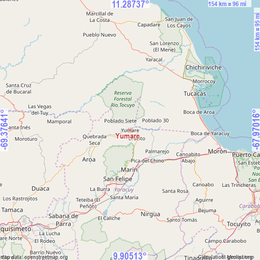
Yumare GPS coordinates[2]
10° 35' 49.308" North, 68° 40' 23.808" West
| Map corner | latitude | longitude |
|---|---|---|
| Upper-left | 11.28737°, | -69.37641° |
| Center: | 10.59703°, | -68.67328° |
| Lower-right: | 9.90513°, | -67.97016° |
| Map W x H: | 153.7×153.7 km | = 95.5×95.5mi |
| max Lat: | 11.94788° ⇑13% North |
| Yumare: | 10.59703° |
| min Lat: | ⇓87% South 1.92027° |
| min Long | Yumare | max Long |
| -72.55212° | -68.67328° | -60.99778° |
| W 51.9%⇐ | ⇒48.1% E |
Elevation
Elevation of Yumare is 64 m = 210 ft, and this is 316.6 m = 1039 ft below average elevation for this country.
| Max E: |
2986 m = 9797 ft | 75.3% |
| Avg. | 380.6 m = 1249 ft | |
| Yumare | 64 m = 210 ft | |
Min E: |
-4 m = -13 ft | 24.7% |
See also: Venezuela elevation on elevation.city.
Geographical zone
Yumare is located in North Torrid zone (between Equator and Tropic of Cancer). Distance of Equator is 1178.3 km =732.2 mi to South.| Distance of | km | miles | from Yumare |
|---|---|---|---|
| North Pole | 8828.8 | 5486 | to North |
| Arctic Circle | 6222.9 | 3866.7 | to North |
| Tropic Cancer | 1427.6 | 887.1 | to North |
| Equator | 1178.3 | 732.2 | to South |


Nearby cities:
15 places around Yumare: (largest is in red/bold)
• Aroa
29.9 km =18.6 mi,  234°
234°
• Boraure
40.3 km =25 mi,  195°
195°
• Chivacoa
54.3 km =33.7 mi,  206°
206°
• Cocorote
33.1 km =20.6 mi, 201°
• Farriar
18.9 km =11.7 mi,  138°
138°
• Guama
40.1 km =24.9 mi, 203°
• Independencia
30.6 km =19 mi, 197°
• Jacura
56.7 km =35.2 mi,  339°
339°
• Morón
53.1 km =33 mi,  103°
103°
• Nirgua
51.1 km =31.8 mi,  166°
166°
• Palmasola
14.1 km =8.8 mi,  91°
91°
• San Felipe
29.6 km =18.4 mi,  194°
194°
• San Pablo
42.9 km =26.7 mi, 205°
• Tucacas
43.6 km =27.1 mi,  60°
60°
• Yaracal
43.7 km =27.2 mi,  18°
18°
Sources, notices
• [Note1] Compared only with cities in Venezuela existing in our database
• [Src1] Map data: © OpenStreetMap contributors (CC-BY-SA)
• [Src2] Other city data from geonames.org with taken over terms of usage.
• [Src3] Geographical zone / Annual Mean Temperature by Robert A. Rohde @ Wikipedia
