Guama geodata
Guama (Yaracuy) is a seat of a second-order administrative division; located in Venezuela in America/Caracas (GMT-4) time zone. In our database, there are 108 cities with bigger population. Compared to other cities in Venezuela, 73% of cities are located further ↓South; 50.1% of cities are located further ←West and 66.2% of cities have lower elevation than Guama. Note1


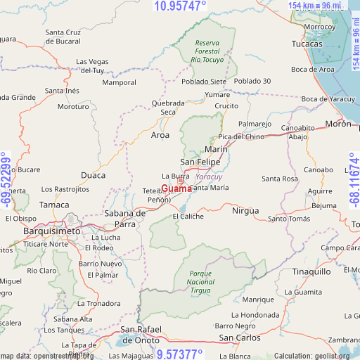
Guama GPS coordinates[2]
10° 15' 58.968" North, 68° 49' 11.496" West
| Map corner | latitude | longitude |
|---|---|---|
| Upper-left | 10.95747°, | -69.52299° |
| Center: | 10.26638°, | -68.81986° |
| Lower-right: | 9.57377°, | -68.11674° |
| Map W x H: | 153.9×153.9 km | = 95.6×95.6mi |
| max Lat: | 11.94788° ⇑27% North |
| Guama: | 10.26638° |
| min Lat: | ⇓73% South 1.92027° |
| min Long | Guama | max Long |
| -72.55212° | -68.81986° | -60.99778° |
| W 50.1%⇐ | ⇒49.9% E |
Elevation
Elevation of Guama is 328 m = 1076 ft, and this is 52.6 m = 173 ft below average elevation for this country.
| Max E: |
2986 m = 9797 ft | 33.8% |
| Avg. | 380.6 m = 1249 ft | |
| Guama | 328 m = 1076 ft | |
Min E: |
-4 m = -13 ft | 66.2% |
See also: Venezuela elevation on elevation.city.
Geographical zone
Guama is located in North Torrid zone (between Equator and Tropic of Cancer). Distance of Equator is 1141.5 km =709.3 mi to South.| Distance of | km | miles | from Guama |
|---|---|---|---|
| North Pole | 8865.5 | 5508.8 | to North |
| Arctic Circle | 6259.7 | 3889.6 | to North |
| Tropic Cancer | 1464.4 | 909.9 | to North |
| Equator | 1141.5 | 709.3 | to South |


Nearby cities:
15 places around Guama: (largest is in red/bold)
• Aroa
20.9 km =13 mi,  336°
336°
• Boraure
5.9 km =3.7 mi,  110°
110°
• Chivacoa
14.4 km =8.9 mi,  214°
214°
• Cocorote
7.2 km =4.5 mi,  34°
34°
• Duaca
37.5 km =23.3 mi,  273°
273°
• Farriar
36.4 km =22.6 mi,  51°
51°
• Independencia
10.4 km =6.5 mi,  43°
43°
• Nirgua
30.7 km =19.1 mi, 114°
• Palmasola
47.2 km =29.3 mi, 39°
• Sabana de Parra
28.7 km =17.8 mi,  235°
235°
• San Felipe
11.8 km =7.3 mi, 45°
• San Pablo
3.3 km =2.1 mi,  234°
234°
• Urachiche
23.8 km =14.8 mi, 239°
• Yaritagua
39.2 km =24.4 mi, 238°
• Yumare
40.1 km =24.9 mi,  23°
23°
Sources, notices
• [Note1] Compared only with cities in Venezuela existing in our database
• [Src1] Map data: © OpenStreetMap contributors (CC-BY-SA)
• [Src2] Other city data from geonames.org with taken over terms of usage.
• [Src3] Geographical zone / Annual Mean Temperature by Robert A. Rohde @ Wikipedia
