Independencia geodata
Independencia (Yaracuy) is a seat of a second-order administrative division; located in Venezuela in America/Caracas (GMT-4) time zone. In our database, there are 108 cities with bigger population. Compared to other cities in Venezuela, 75.8% of cities are located further ↓South; 50.9% of cities are located further ←West and 66.4% of cities have lower elevation than Independencia. Note1


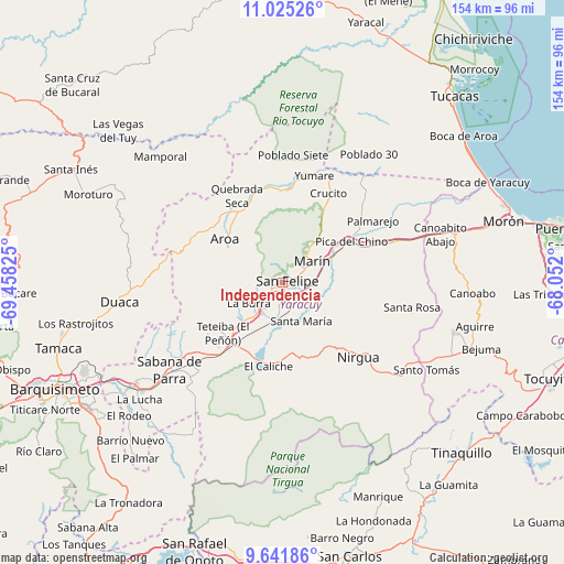
Independencia GPS coordinates[2]
10° 20' 3.552" North, 68° 45' 18.432" West
| Map corner | latitude | longitude |
|---|---|---|
| Upper-left | 11.02526°, | -69.45825° |
| Center: | 10.33432°, | -68.75512° |
| Lower-right: | 9.64186°, | -68.052° |
| Map W x H: | 153.8×153.8 km | = 95.6×95.6mi |
| max Lat: | 11.94788° ⇑24.2% North |
| Independencia: | 10.33432° |
| min Lat: | ⇓75.8% South 1.92027° |
| min Long | Independencia | max Long |
| -72.55212° | -68.75512° | -60.99778° |
| W 50.9%⇐ | ⇒49.1% E |
Elevation
Elevation of Independencia is 335 m = 1099 ft, and this is 45.6 m = 150 ft below average elevation for this country.
| Max E: |
2986 m = 9797 ft | 33.6% |
| Avg. | 380.6 m = 1249 ft | |
| Independencia | 335 m = 1099 ft | |
Min E: |
-4 m = -13 ft | 66.4% |
See also: Venezuela elevation on elevation.city.
Geographical zone
Independencia is located in North Torrid zone (between Equator and Tropic of Cancer). Distance of Equator is 1149.1 km =714 mi to South.| Distance of | km | miles | from Independencia |
|---|---|---|---|
| North Pole | 8858 | 5504.1 | to North |
| Arctic Circle | 6252.1 | 3884.9 | to North |
| Tropic Cancer | 1456.9 | 905.3 | to North |
| Equator | 1149.1 | 714 | to South |


Nearby cities:
15 places around Independencia: (largest is in red/bold)
• Aroa
19.3 km =12 mi,  307°
307°
• Boraure
9.8 km =6.1 mi,  189°
189°
• Chivacoa
24.7 km =15.3 mi,  218°
218°
• Cocorote
3.5 km =2.2 mi,  241°
241°
• Duaca
44.9 km =27.9 mi,  263°
263°
• Farriar
26.2 km =16.3 mi,  54°
54°
• Guama
10.4 km =6.5 mi, 223°
• Miranda
44.5 km =27.7 mi,  117°
117°
• Nirgua
29.2 km =18.1 mi,  134°
134°
• Palmasola
36.9 km =22.9 mi,  38°
38°
• Sabana de Parra
38.8 km =24.1 mi,  232°
232°
• San Felipe
1.5 km =0.9 mi,  65°
65°
• San Pablo
13.6 km =8.5 mi, 225°
• Urachiche
33.9 km =21.1 mi, 234°
• Yumare
30.6 km =19 mi,  17°
17°
Sources, notices
• [Note1] Compared only with cities in Venezuela existing in our database
• [Src1] Map data: © OpenStreetMap contributors (CC-BY-SA)
• [Src2] Other city data from geonames.org with taken over terms of usage.
• [Src3] Geographical zone / Annual Mean Temperature by Robert A. Rohde @ Wikipedia
