Anaco geodata
Anaco (Anzoátegui) is a seat of a second-order administrative division; located in Venezuela in America/Caracas (GMT-4) time zone. With population of 117,596 people, there are 36 cities with bigger population in this country. Compared to other cities in Venezuela, 53.2% of cities are located further ↑North; 85.5% of cities are located further ←West and 55% of cities have lower elevation than Anaco. Note1


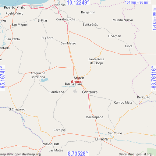
Anaco GPS coordinates[2]
9° 25' 46.488" North, 64° 27' 51.408" West
| Map corner | latitude | longitude |
|---|---|---|
| Upper-left | 10.12249°, | -65.16741° |
| Center: | 9.42958°, | -64.46428° |
| Lower-right: | 8.73528°, | -63.76116° |
| Map W x H: | 154.2×154.2 km | = 95.8×95.8mi |
| max Lat: | 11.94788° ⇑53.2% North |
| Anaco: | 9.42958° |
| min Lat: | ⇓46.8% South 1.92027° |
| min Long | Anaco | max Long |
| -72.55212° | -64.46428° | -60.99778° |
| W 85.5%⇐ | ⇒14.5% E |
Elevation
Elevation of Anaco is 208 m = 682 ft, and this is 172.6 m = 566 ft below average elevation for this country.
| Max E: |
2986 m = 9797 ft | 45% |
| Avg. | 380.6 m = 1249 ft | |
| Anaco | 208 m = 682 ft | |
Min E: |
-4 m = -13 ft | 55% |
See also: Anaco elevation on elevation.city.
Geographical zone
Anaco is located in North Torrid zone (between Equator and Tropic of Cancer). Distance of Equator is 1048.5 km =651.5 mi to South.| Distance of | km | miles | from Anaco |
|---|---|---|---|
| North Pole | 8958.6 | 5566.6 | to North |
| Arctic Circle | 6352.7 | 3947.4 | to North |
| Tropic Cancer | 1557.4 | 967.7 | to North |
| Equator | 1048.5 | 651.5 | to South |


Nearby cities:
15 places around Anaco: (largest is in red/bold)
• Aguasay
80.5 km =50 mi,  90°
90°
• Aragua de Barcelona
40.1 km =24.9 mi,  274°
274°
• Barcelona
82.3 km =51.1 mi,  342°
342°
• Cantaura
18 km =11.2 mi,  139°
139°
• El Chaparro
68.1 km =42.3 mi,  243°
243°
• El Tigre
64.4 km =40 mi,  158°
158°
• Guanta
90.7 km =56.4 mi,  350°
350°
• Lecherías
88.3 km =54.9 mi, 343°
• Onoto
82.1 km =51 mi,  283°
283°
• Pariaguán
70.5 km =43.8 mi,  202°
202°
• Puerto La Cruz
89.1 km =55.4 mi, 348°
• Píritu
91.9 km =57.1 mi,  317°
317°
• San José de Guanipa
68.7 km =42.7 mi,  151°
151°
• San Mateo
35.8 km =22.2 mi, 344°
• Santa Ana
25 km =15.5 mi, 236°
Sources, notices
• [Note1] Compared only with cities in Venezuela existing in our database
• [Src1] Map data: © OpenStreetMap contributors (CC-BY-SA)
• [Src2] Other city data from geonames.org with taken over terms of usage.
• [Src3] Geographical zone / Annual Mean Temperature by Robert A. Rohde @ Wikipedia
