San Mateo geodata
San Mateo (Anzoátegui) is a seat of a second-order administrative division; located in Venezuela in America/Caracas (GMT-4) time zone. In our database, there are 108 cities with bigger population. Compared to other cities in Venezuela, 52.9% of cities are located further ↓South; 85.2% of cities are located further ←West and 59.5% of cities have higher elevation than San Mateo. Note1


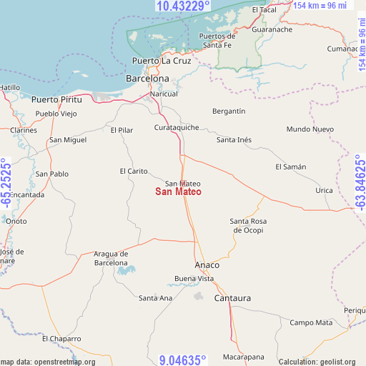
San Mateo GPS coordinates[2]
9° 44' 24.144" North, 64° 32' 57.732" West
| Map corner | latitude | longitude |
|---|---|---|
| Upper-left | 10.43229°, | -65.2525° |
| Center: | 9.74004°, | -64.54937° |
| Lower-right: | 9.04635°, | -63.84625° |
| Map W x H: | 154.1×154.1 km | = 95.8×95.8mi |
| max Lat: | 11.94788° ⇑47.1% North |
| San Mateo: | 9.74004° |
| min Lat: | ⇓52.9% South 1.92027° |
| min Long | San Mateo | max Long |
| -72.55212° | -64.54937° | -60.99778° |
| W 85.2%⇐ | ⇒14.8% E |
Elevation
Elevation of San Mateo is 136 m = 446 ft, and this is 244.6 m = 802 ft below average elevation for this country.
| Max E: |
2986 m = 9797 ft | 59.5% |
| Avg. | 380.6 m = 1249 ft | |
| San Mateo | 136 m = 446 ft | |
Min E: |
-4 m = -13 ft | 40.5% |
See also: Venezuela elevation on elevation.city.
Geographical zone
San Mateo is located in North Torrid zone (between Equator and Tropic of Cancer). Distance of Equator is 1083 km =672.9 mi to South.| Distance of | km | miles | from San Mateo |
|---|---|---|---|
| North Pole | 8924.1 | 5545.2 | to North |
| Arctic Circle | 6318.2 | 3925.9 | to North |
| Tropic Cancer | 1522.9 | 946.3 | to North |
| Equator | 1083 | 672.9 | to South |


Nearby cities:
15 places around San Mateo: (largest is in red/bold)
• Anaco
35.8 km =22.2 mi,  164°
164°
• Aragua de Barcelona
44 km =27.3 mi,  224°
224°
• Barcelona
46.5 km =28.9 mi,  341°
341°
• Cantaura
52.6 km =32.7 mi, 156°
• Clarines
71 km =44.1 mi,  288°
288°
• Cumanacoa
89.3 km =55.5 mi,  50°
50°
• Cumaná
89 km =55.3 mi,  26°
26°
• El Chaparro
83.1 km =51.6 mi, 218°
• Guanta
55.2 km =34.3 mi,  354°
354°
• Lecherías
52.6 km =32.7 mi, 342°
• Onoto
72.4 km =45 mi,  257°
257°
• Puerto La Cruz
53.5 km =33.2 mi, 350°
• Puerto Píritu
64.1 km =39.8 mi,  303°
303°
• Píritu
62.3 km =38.7 mi, 302°
• Santa Ana
49.7 km =30.9 mi,  193°
193°
Sources, notices
• [Note1] Compared only with cities in Venezuela existing in our database
• [Src1] Map data: © OpenStreetMap contributors (CC-BY-SA)
• [Src2] Other city data from geonames.org with taken over terms of usage.
• [Src3] Geographical zone / Annual Mean Temperature by Robert A. Rohde @ Wikipedia
