Clarines geodata
Clarines (Anzoátegui) is a seat of a second-order administrative division; located in Venezuela in America/Caracas (GMT-4) time zone. In our database, there are 108 cities with bigger population. Compared to other cities in Venezuela, 57% of cities are located further ↓South; 82.2% of cities are located further ←West and 85.5% of cities have higher elevation than Clarines. Note1


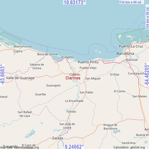
Clarines GPS coordinates[2]
9° 56' 23.676" North, 65° 9' 54.612" West
| Map corner | latitude | longitude |
|---|---|---|
| Upper-left | 10.63173°, | -65.8683° |
| Center: | 9.93991°, | -65.16517° |
| Lower-right: | 9.24662°, | -64.46205° |
| Map W x H: | 154×154 km | = 95.7×95.7mi |
| max Lat: | 11.94788° ⇑43% North |
| Clarines: | 9.93991° |
| min Lat: | ⇓57% South 1.92027° |
| min Long | Clarines | max Long |
| -72.55212° | -65.16517° | -60.99778° |
| W 82.2%⇐ | ⇒17.8% E |
Elevation
Elevation of Clarines is 29 m = 95 ft, and this is 351.6 m = 1154 ft below average elevation for this country.
| Max E: |
2986 m = 9797 ft | 85.5% |
| Avg. | 380.6 m = 1249 ft | |
| Clarines | 29 m = 95 ft | |
Min E: |
-4 m = -13 ft | 14.5% |
See also: Venezuela elevation on elevation.city.
Geographical zone
Clarines is located in North Torrid zone (between Equator and Tropic of Cancer). Distance of Equator is 1105.2 km =686.7 mi to South.| Distance of | km | miles | from Clarines |
|---|---|---|---|
| North Pole | 8901.8 | 5531.3 | to North |
| Arctic Circle | 6296 | 3912.2 | to North |
| Tropic Cancer | 1500.7 | 932.5 | to North |
| Equator | 1105.2 | 686.7 | to South |


Nearby cities:
15 places around Clarines: (largest is in red/bold)
• Aragua de Barcelona
65.2 km =40.5 mi,  145°
145°
• Barcelona
56.8 km =35.3 mi,  67°
67°
• Boca de Uchire
35.3 km =21.9 mi,  307°
307°
• Cúpira
63.5 km =39.5 mi,  292°
292°
• El Chaparro
89.1 km =55.4 mi,  169°
169°
• Guanta
70.3 km =43.7 mi,  62°
62°
• Lecherías
58.9 km =36.6 mi, 61°
• Onoto
38.2 km =23.7 mi,  184°
184°
• Puerto La Cruz
65.8 km =40.9 mi, 62°
• Puerto Píritu
19.3 km =12 mi,  46°
46°
• Píritu
18.5 km =11.5 mi, 53°
• San José de Guaribe
71.5 km =44.4 mi,  262°
262°
• San Mateo
71 km =44.1 mi,  108°
108°
• Valle de Guanape
55.8 km =34.7 mi,  266°
266°
• Zaraza
67.8 km =42.1 mi,  194°
194°
Sources, notices
• [Note1] Compared only with cities in Venezuela existing in our database
• [Src1] Map data: © OpenStreetMap contributors (CC-BY-SA)
• [Src2] Other city data from geonames.org with taken over terms of usage.
• [Src3] Geographical zone / Annual Mean Temperature by Robert A. Rohde @ Wikipedia
