Mucumpiz geodata
Mucumpiz (Mérida) is a populated place; located in Venezuela in America/Caracas (GMT-4) time zone. With population of 215,259 people, there are 19 cities with bigger population in this country. Compared to other cities in Venezuela, 76.3% of cities are located further ↑North; 81.9% of cities are located further →East and 99.7% of cities have lower elevation than Mucumpiz. Note1


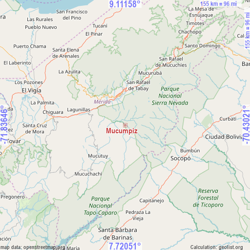
Mucumpiz GPS coordinates[2]
8° 25' 0.012" North, 71° 7' 59.988" West
| Map corner | latitude | longitude |
|---|---|---|
| Upper-left | 9.11158°, | -71.83646° |
| Center: | 8.41667°, | -71.13333° |
| Lower-right: | 7.72051°, | -70.43021° |
| Map W x H: | 154.7×154.7 km | = 96.1×96.1mi |
| max Lat: | 11.94788° ⇑76.3% North |
| Mucumpiz: | 8.41667° |
| min Lat: | ⇓23.7% South 1.92027° |
| min Long | Mucumpiz | max Long |
| -72.55212° | -71.13333° | -60.99778° |
| W 18.1%⇐ | ⇒81.9% E |
Elevation
Elevation of Mucumpiz is 2236 m = 7336 ft, and this is 1855.4 m = 6087 ft above average elevation for this country.
| Max E: |
2986 m = 9797 ft | 0.3% |
| Mucumpiz | 2236 m 7336 ft | |
| Avg. | 380.6 m = 1249 ft | |
Min E: |
-4 m = -13 ft | 99.7% |
See also: Mucumpiz elevation on elevation.city.
Geographical zone
Mucumpiz is located in North Torrid zone (between Equator and Tropic of Cancer). Distance of Equator is 935.8 km =581.5 mi to South.| Distance of | km | miles | from Mucumpiz |
|---|---|---|---|
| North Pole | 9071.2 | 5636.6 | to North |
| Arctic Circle | 6465.3 | 4017.3 | to North |
| Tropic Cancer | 1670.1 | 1037.8 | to North |
| Equator | 935.8 | 581.5 | to South |


Nearby cities:
15 places around Mucumpiz: (largest is in red/bold)
• Aricagua
21.4 km =13.3 mi,  181°
181°
• Bum Bum
43.2 km =26.8 mi,  111°
111°
• Canaguá
48.5 km =30.1 mi,  227°
227°
• Capitanejo
47.2 km =29.3 mi,  162°
162°
• Chameta
43.1 km =26.8 mi,  144°
144°
• Ejido
18.7 km =11.6 mi,  320°
320°
• La Azulita
47.5 km =29.5 mi,  314°
314°
• Lagunillas
29.8 km =18.5 mi,  289°
289°
• Mucuchíes
43.8 km =27.2 mi,  32°
32°
• Mérida
19.4 km =12.1 mi,  352°
352°
• Pedraza La Vieja
56.2 km =34.9 mi,  171°
171°
• Santa Cruz de Mora
55.9 km =34.7 mi,  268°
268°
• Santa Elena de Arenales
57.9 km =36 mi, 320°
• Socopó
40 km =24.9 mi,  121°
121°
• Tabay
24.7 km =15.3 mi,  14°
14°
Sources, notices
• [Note1] Compared only with cities in Venezuela existing in our database
• [Src1] Map data: © OpenStreetMap contributors (CC-BY-SA)
• [Src2] Other city data from geonames.org with taken over terms of usage.
• [Src3] Geographical zone / Annual Mean Temperature by Robert A. Rohde @ Wikipedia
