Mérida geodata
Mérida is a seat of a first-order administrative division; located in Venezuela in America/Caracas (GMT-4) time zone. With population of 300,000 people, there are 13 cities with bigger population in this country. Compared to other cities in Venezuela, 72.8% of cities are located further ↑North; 82.4% of cities are located further →East and 96.2% of cities have lower elevation than Mérida. Note1


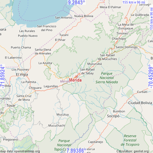
Mérida GPS coordinates[2]
8° 35' 22.992" North, 71° 9' 21.996" West
| Map corner | latitude | longitude |
|---|---|---|
| Upper-left | 9.2843°, | -71.85924° |
| Center: | 8.58972°, | -71.15611° |
| Lower-right: | 7.89386°, | -70.45299° |
| Map W x H: | 154.6×154.6 km | = 96.1×96.1mi |
| max Lat: | 11.94788° ⇑72.8% North |
| Mérida: | 8.58972° |
| min Lat: | ⇓27.2% South 1.92027° |
| min Long | Mérida | max Long |
| -72.55212° | -71.15611° | -60.99778° |
| W 17.6%⇐ | ⇒82.4% E |
Elevation
Elevation of Mérida is 1544 m = 5066 ft, and this is 1163.4 m = 3817 ft above average elevation for this country.
| Max E: |
2986 m = 9797 ft | 3.8% |
| Mérida | 1544 m 5066 ft | |
| Avg. | 380.6 m = 1249 ft | |
Min E: |
-4 m = -13 ft | 96.2% |
See also: Mérida elevation on elevation.city.
Geographical zone
Mérida is located in North Torrid zone (between Equator and Tropic of Cancer). Distance of Equator is 955.1 km =593.5 mi to South.| Distance of | km | miles | from Mérida |
|---|---|---|---|
| North Pole | 9052 | 5624.7 | to North |
| Arctic Circle | 6446.1 | 4005.4 | to North |
| Tropic Cancer | 1650.8 | 1025.8 | to North |
| Equator | 955.1 | 593.5 | to South |


Nearby cities:
15 places around Mérida: (largest is in red/bold)
• Aricagua
40.7 km =25.3 mi,  177°
177°
• Bum Bum
55.2 km =34.3 mi,  129°
129°
• Ejido
10.5 km =6.5 mi,  242°
242°
• El Vigía
55.1 km =34.2 mi,  272°
272°
• La Azulita
34.5 km =21.4 mi,  293°
293°
• Lagunillas
27.3 km =17 mi,  249°
249°
• Mucuchíes
31.5 km =19.6 mi,  55°
55°
• Mucumpiz
19.4 km =12.1 mi,  172°
172°
• Santa Cruz de Mora
57.4 km =35.7 mi, 248°
• Santa Elena de Arenales
42.6 km =26.5 mi,  307°
307°
• Santo Domingo
59 km =36.7 mi, 59°
• Socopó
54.3 km =33.7 mi,  137°
137°
• Tabay
9.7 km =6 mi, 61°
• Torondoy
51.9 km =32.2 mi,  17°
17°
• Tucaní
44.2 km =27.5 mi,  343°
343°
Sources, notices
• [Note1] Compared only with cities in Venezuela existing in our database
• [Src1] Map data: © OpenStreetMap contributors (CC-BY-SA)
• [Src2] Other city data from geonames.org with taken over terms of usage.
• [Src3] Geographical zone / Annual Mean Temperature by Robert A. Rohde @ Wikipedia
