Maripa geodata
Maripa (Bolívar) is a seat of a second-order administrative division; located in Venezuela in America/Caracas (GMT-4) time zone. In our database, there are 108 cities with bigger population. Compared to other cities in Venezuela, 96.9% of cities are located further ↑North; 81.9% of cities are located further ←West and 81.4% of cities have higher elevation than Maripa. Note1


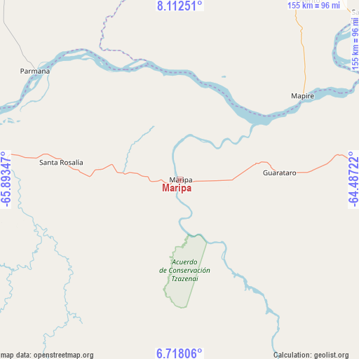
Maripa GPS coordinates[2]
7° 24' 57.024" North, 65° 11' 25.224" West
| Map corner | latitude | longitude |
|---|---|---|
| Upper-left | 8.11251°, | -65.89347° |
| Center: | 7.41584°, | -65.19034° |
| Lower-right: | 6.71806°, | -64.48722° |
| Map W x H: | 155×155.1 km | = 96.3×96.4mi |
| max Lat: | 11.94788° ⇑96.9% North |
| Maripa: | 7.41584° |
| min Lat: | ⇓3.1% South 1.92027° |
| min Long | Maripa | max Long |
| -72.55212° | -65.19034° | -60.99778° |
| W 81.9%⇐ | ⇒18.1% E |
Elevation
Elevation of Maripa is 43 m = 141 ft, and this is 337.6 m = 1108 ft below average elevation for this country.
| Max E: |
2986 m = 9797 ft | 81.4% |
| Avg. | 380.6 m = 1249 ft | |
| Maripa | 43 m = 141 ft | |
Min E: |
-4 m = -13 ft | 18.6% |
See also: Venezuela elevation on elevation.city.
Geographical zone
Maripa is located in North Torrid zone (between Equator and Tropic of Cancer). Distance of Equator is 824.6 km =512.4 mi to South.| Distance of | km | miles | from Maripa |
|---|---|---|---|
| North Pole | 9182.5 | 5705.7 | to North |
| Arctic Circle | 6576.6 | 4086.5 | to North |
| Tropic Cancer | 1781.4 | 1106.9 | to North |
| Equator | 824.6 | 512.4 | to South |


Nearby cities:
15 places around Maripa: (largest is in red/bold)
• Caicara del Orinoco
110.5 km =68.7 mi,  282°
282°
• Ciudad Bolívar
198.3 km =123.2 mi,  66°
66°
• Ciudad Piar
206.3 km =128.2 mi,  88°
88°
• El Chaparro
194 km =120.5 mi,  5°
5°
• El Socorro
185.6 km =115.3 mi,  340°
340°
• El Tigre
193.6 km =120.3 mi,  32°
32°
• Mapire
64.1 km =39.8 mi,  55°
55°
• Pariaguán
167.3 km =104 mi,  18°
18°
• San José de Guanipa
198.7 km =123.5 mi, 34°
• Santa Ana
218.2 km =135.6 mi, 15°
• Santa María de Ipire
156.3 km =97.1 mi,  354°
354°
• Soledad
197.3 km =122.6 mi, 65°
• Tucupido
216.2 km =134.3 mi, 342°
• Valle de La Pascua
219.4 km =136.3 mi, 335°
• Zaraza
215.6 km =134 mi,  356°
356°
Sources, notices
• [Note1] Compared only with cities in Venezuela existing in our database
• [Src1] Map data: © OpenStreetMap contributors (CC-BY-SA)
• [Src2] Other city data from geonames.org with taken over terms of usage.
• [Src3] Geographical zone / Annual Mean Temperature by Robert A. Rohde @ Wikipedia
