Guaraque geodata
Guaraque (Mérida) is a seat of a second-order administrative division; located in Venezuela in America/Caracas (GMT-4) time zone. In our database, there are 108 cities with bigger population. Compared to other cities in Venezuela, 82.4% of cities are located further ↑North; 89.6% of cities are located further →East and 96.7% of cities have lower elevation than Guaraque. Note1


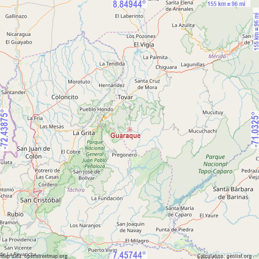
Guaraque GPS coordinates[2]
8° 9' 14.58" North, 71° 44' 8.232" West
| Map corner | latitude | longitude |
|---|---|---|
| Upper-left | 8.84944°, | -72.43875° |
| Center: | 8.15405°, | -71.73562° |
| Lower-right: | 7.45744°, | -71.0325° |
| Map W x H: | 154.8×154.8 km | = 96.2×96.2mi |
| max Lat: | 11.94788° ⇑82.4% North |
| Guaraque: | 8.15405° |
| min Lat: | ⇓17.6% South 1.92027° |
| min Long | Guaraque | max Long |
| -72.55212° | -71.73562° | -60.99778° |
| W 10.4%⇐ | ⇒89.6% E |
Elevation
Elevation of Guaraque is 1557 m = 5108 ft, and this is 1176.4 m = 3860 ft above average elevation for this country.
| Max E: |
2986 m = 9797 ft | 3.3% |
| Guaraque | 1557 m 5108 ft | |
| Avg. | 380.6 m = 1249 ft | |
Min E: |
-4 m = -13 ft | 96.7% |
See also: Venezuela elevation on elevation.city.
Geographical zone
Guaraque is located in North Torrid zone (between Equator and Tropic of Cancer). Distance of Equator is 906.6 km =563.3 mi to South.| Distance of | km | miles | from Guaraque |
|---|---|---|---|
| North Pole | 9100.4 | 5654.7 | to North |
| Arctic Circle | 6494.5 | 4035.5 | to North |
| Tropic Cancer | 1699.3 | 1055.9 | to North |
| Equator | 906.6 | 563.3 | to South |


Nearby cities:
15 places around Guaraque: (largest is in red/bold)
• Bailadores
15 km =9.3 mi,  317°
317°
• Canaguá
30.5 km =19 mi,  96°
96°
• El Cobre
37.8 km =23.5 mi,  249°
249°
• La Grita
27.4 km =17 mi,  265°
265°
• La Tendida
40.7 km =25.3 mi,  344°
344°
• Pregonero
15.4 km =9.6 mi,  192°
192°
• Queniquea
40.4 km =25.1 mi,  229°
229°
• San José de Bolívar
37.4 km =23.2 mi,  224°
224°
• San Simón
25.2 km =15.7 mi,  329°
329°
• Santa Ana
31.8 km =19.8 mi,  262°
262°
• Santa Cruz de Mora
29.2 km =18.1 mi,  20°
20°
• Seboruco
37.2 km =23.1 mi, 268°
• Tovar
19.7 km =12.2 mi,  354°
354°
• Umuquena
38.3 km =23.8 mi,  289°
289°
• Zea
25.4 km =15.8 mi, 347°
Sources, notices
• [Note1] Compared only with cities in Venezuela existing in our database
• [Src1] Map data: © OpenStreetMap contributors (CC-BY-SA)
• [Src2] Other city data from geonames.org with taken over terms of usage.
• [Src3] Geographical zone / Annual Mean Temperature by Robert A. Rohde @ Wikipedia
