Tovar geodata
Tovar (Mérida) is a seat of a second-order administrative division; located in Venezuela in America/Caracas (GMT-4) time zone. In our database, there are 108 cities with bigger population. Compared to other cities in Venezuela, 78.4% of cities are located further ↑North; 89.8% of cities are located further →East and 90.6% of cities have lower elevation than Tovar. Note1


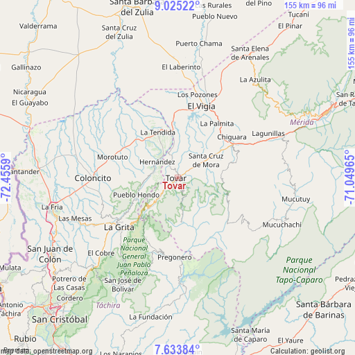
Tovar GPS coordinates[2]
8° 19' 48.54" North, 71° 45' 9.972" West
| Map corner | latitude | longitude |
|---|---|---|
| Upper-left | 9.02522°, | -72.4559° |
| Center: | 8.33015°, | -71.75277° |
| Lower-right: | 7.63384°, | -71.04965° |
| Map W x H: | 154.7×154.7 km | = 96.1×96.1mi |
| max Lat: | 11.94788° ⇑78.4% North |
| Tovar: | 8.33015° |
| min Lat: | ⇓21.6% South 1.92027° |
| min Long | Tovar | max Long |
| -72.55212° | -71.75277° | -60.99778° |
| W 10.2%⇐ | ⇒89.8% E |
Elevation
Elevation of Tovar is 1107 m = 3632 ft, and this is 726.4 m = 2383 ft above average elevation for this country.
| Max E: |
2986 m = 9797 ft | 9.4% |
| Tovar | 1107 m 3632 ft | |
| Avg. | 380.6 m = 1249 ft | |
Min E: |
-4 m = -13 ft | 90.6% |
See also: Venezuela elevation on elevation.city.
Geographical zone
Tovar is located in North Torrid zone (between Equator and Tropic of Cancer). Distance of Equator is 926.2 km =575.5 mi to South.| Distance of | km | miles | from Tovar |
|---|---|---|---|
| North Pole | 9080.8 | 5642.5 | to North |
| Arctic Circle | 6474.9 | 4023.3 | to North |
| Tropic Cancer | 1679.7 | 1043.7 | to North |
| Equator | 926.2 | 575.5 | to South |


Nearby cities:
15 places around Tovar: (largest is in red/bold)
• Bailadores
11.9 km =7.4 mi,  224°
224°
• Canaguá
39.4 km =24.5 mi,  125°
125°
• Coloncito
36.8 km =22.9 mi,  269°
269°
• El Vigía
33.2 km =20.6 mi,  18°
18°
• Guaraque
19.7 km =12.2 mi,  174°
174°
• La Grita
33.6 km =20.9 mi,  229°
229°
• La Tendida
21.5 km =13.4 mi,  336°
336°
• Lagunillas
44.4 km =27.6 mi,  64°
64°
• Pregonero
34.6 km =21.5 mi,  182°
182°
• San Simón
11 km =6.8 mi,  281°
281°
• Santa Ana
37.9 km =23.5 mi, 231°
• Santa Cruz de Mora
14.5 km =9 mi, 58°
• Seboruco
40.8 km =25.4 mi,  239°
239°
• Umuquena
35 km =21.7 mi,  258°
258°
• Zea
6.2 km =3.9 mi,  326°
326°
Sources, notices
• [Note1] Compared only with cities in Venezuela existing in our database
• [Src1] Map data: © OpenStreetMap contributors (CC-BY-SA)
• [Src2] Other city data from geonames.org with taken over terms of usage.
• [Src3] Geographical zone / Annual Mean Temperature by Robert A. Rohde @ Wikipedia
