San Simón geodata
San Simón (Táchira) is a seat of a second-order administrative division; located in Venezuela in America/Caracas (GMT-4) time zone. In our database, there are 108 cities with bigger population. Compared to other cities in Venezuela, 78.1% of cities are located further ↑North; 91.9% of cities are located further →East and 91.9% of cities have lower elevation than San Simón. Note1


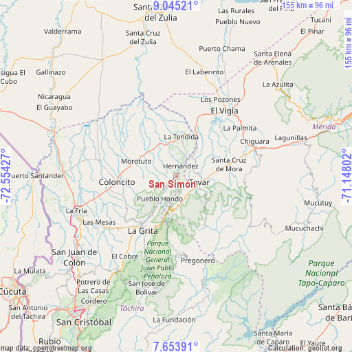
San Simón GPS coordinates[2]
8° 21' 0.648" North, 71° 51' 4.104" West
| Map corner | latitude | longitude |
|---|---|---|
| Upper-left | 9.04521°, | -72.55427° |
| Center: | 8.35018°, | -71.85114° |
| Lower-right: | 7.65391°, | -71.14802° |
| Map W x H: | 154.7×154.7 km | = 96.1×96.1mi |
| max Lat: | 11.94788° ⇑78.1% North |
| San Simón: | 8.35018° |
| min Lat: | ⇓21.9% South 1.92027° |
| min Long | San Simón | max Long |
| -72.55212° | -71.85114° | -60.99778° |
| W 8.1%⇐ | ⇒91.9% E |
Elevation
Elevation of San Simón is 1150 m = 3773 ft, and this is 769.4 m = 2524 ft above average elevation for this country.
| Max E: |
2986 m = 9797 ft | 8.1% |
| San Simón | 1150 m 3773 ft | |
| Avg. | 380.6 m = 1249 ft | |
Min E: |
-4 m = -13 ft | 91.9% |
See also: Venezuela elevation on elevation.city.
Geographical zone
San Simón is located in North Torrid zone (between Equator and Tropic of Cancer). Distance of Equator is 928.5 km =576.9 mi to South.| Distance of | km | miles | from San Simón |
|---|---|---|---|
| North Pole | 9078.6 | 5641.2 | to North |
| Arctic Circle | 6472.7 | 4021.9 | to North |
| Tropic Cancer | 1677.5 | 1042.3 | to North |
| Equator | 928.5 | 576.9 | to South |


Nearby cities:
15 places around San Simón: (largest is in red/bold)
• Bailadores
11 km =6.8 mi,  166°
166°
• Coloncito
26.1 km =16.2 mi,  264°
264°
• El Cobre
41.8 km =26 mi,  212°
212°
• El Vigía
36.2 km =22.5 mi,  36°
36°
• Guaraque
25.2 km =15.7 mi,  149°
149°
• La Grita
28.2 km =17.5 mi, 211°
• La Tendida
17.6 km =10.9 mi,  6°
6°
• Las Mesas
39.3 km =24.4 mi,  239°
239°
• Pregonero
38 km =23.6 mi, 165°
• Santa Ana
32 km =19.9 mi,  215°
215°
• Santa Cruz de Mora
23.8 km =14.8 mi,  76°
76°
• Seboruco
33.4 km =20.8 mi,  227°
227°
• Tovar
11 km =6.8 mi,  101°
101°
• Umuquena
25.2 km =15.7 mi,  248°
248°
• Zea
8 km =5 mi,  67°
67°
Sources, notices
• [Note1] Compared only with cities in Venezuela existing in our database
• [Src1] Map data: © OpenStreetMap contributors (CC-BY-SA)
• [Src2] Other city data from geonames.org with taken over terms of usage.
• [Src3] Geographical zone / Annual Mean Temperature by Robert A. Rohde @ Wikipedia
