Bailadores geodata
Bailadores (Mérida) is a seat of a second-order administrative division; located in Venezuela in America/Caracas (GMT-4) time zone. In our database, there are 108 cities with bigger population. Compared to other cities in Venezuela, 80.4% of cities are located further ↑North; 90.8% of cities are located further →East and 98% of cities have lower elevation than Bailadores. Note1


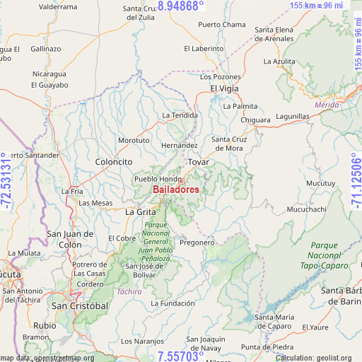
Bailadores GPS coordinates[2]
8° 15' 12.492" North, 71° 49' 41.448" West
| Map corner | latitude | longitude |
|---|---|---|
| Upper-left | 8.94868°, | -72.53131° |
| Center: | 8.25347°, | -71.82818° |
| Lower-right: | 7.55703°, | -71.12506° |
| Map W x H: | 154.7×154.7 km | = 96.1×96.1mi |
| max Lat: | 11.94788° ⇑80.4% North |
| Bailadores: | 8.25347° |
| min Lat: | ⇓19.6% South 1.92027° |
| min Long | Bailadores | max Long |
| -72.55212° | -71.82818° | -60.99778° |
| W 9.2%⇐ | ⇒90.8% E |
Elevation
Elevation of Bailadores is 1710 m = 5610 ft, and this is 1329.4 m = 4362 ft above average elevation for this country.
| Max E: |
2986 m = 9797 ft | 2% |
| Bailadores | 1710 m 5610 ft | |
| Avg. | 380.6 m = 1249 ft | |
Min E: |
-4 m = -13 ft | 98% |
See also: Venezuela elevation on elevation.city.
Geographical zone
Bailadores is located in North Torrid zone (between Equator and Tropic of Cancer). Distance of Equator is 917.7 km =570.2 mi to South.| Distance of | km | miles | from Bailadores |
|---|---|---|---|
| North Pole | 9089.4 | 5647.9 | to North |
| Arctic Circle | 6483.5 | 4028.7 | to North |
| Tropic Cancer | 1688.2 | 1049 | to North |
| Equator | 917.7 | 570.2 | to South |


Nearby cities:
15 places around Bailadores: (largest is in red/bold)
• Coloncito
29.6 km =18.4 mi,  285°
285°
• El Cobre
35 km =21.7 mi,  226°
226°
• Guaraque
15 km =9.3 mi,  137°
137°
• La Grita
21.7 km =13.5 mi, 232°
• La Tendida
28.2 km =17.5 mi,  359°
359°
• Las Mesas
37.6 km =23.4 mi,  255°
255°
• Pregonero
26.9 km =16.7 mi,  165°
165°
• San José de Bolívar
41.1 km =25.5 mi,  202°
202°
• San Simón
11 km =6.8 mi,  346°
346°
• Santa Ana
26.2 km =16.3 mi, 234°
• Santa Cruz de Mora
26.2 km =16.3 mi,  51°
51°
• Seboruco
29.5 km =18.3 mi,  245°
245°
• Tovar
11.9 km =7.4 mi,  44°
44°
• Umuquena
26 km =16.2 mi,  273°
273°
• Zea
14.6 km =9.1 mi,  19°
19°
Sources, notices
• [Note1] Compared only with cities in Venezuela existing in our database
• [Src1] Map data: © OpenStreetMap contributors (CC-BY-SA)
• [Src2] Other city data from geonames.org with taken over terms of usage.
• [Src3] Geographical zone / Annual Mean Temperature by Robert A. Rohde @ Wikipedia
