Zea geodata
Zea (Mérida) is a seat of a second-order administrative division; located in Venezuela in America/Caracas (GMT-4) time zone. In our database, there are 108 cities with bigger population. Compared to other cities in Venezuela, 77.4% of cities are located further ↑North; 90.6% of cities are located further →East and 92.1% of cities have lower elevation than Zea. Note1


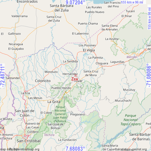
Zea GPS coordinates[2]
8° 22' 37.416" North, 71° 47' 2.328" West
| Map corner | latitude | longitude |
|---|---|---|
| Upper-left | 9.07204°, | -72.48711° |
| Center: | 8.37706°, | -71.78398° |
| Lower-right: | 7.68083°, | -71.08086° |
| Map W x H: | 154.7×154.7 km | = 96.1×96.1mi |
| max Lat: | 11.94788° ⇑77.4% North |
| Zea: | 8.37706° |
| min Lat: | ⇓22.6% South 1.92027° |
| min Long | Zea | max Long |
| -72.55212° | -71.78398° | -60.99778° |
| W 9.4%⇐ | ⇒90.6% E |
Elevation
Elevation of Zea is 1151 m = 3776 ft, and this is 770.4 m = 2528 ft above average elevation for this country.
| Max E: |
2986 m = 9797 ft | 7.9% |
| Zea | 1151 m 3776 ft | |
| Avg. | 380.6 m = 1249 ft | |
Min E: |
-4 m = -13 ft | 92.1% |
See also: Venezuela elevation on elevation.city.
Geographical zone
Zea is located in North Torrid zone (between Equator and Tropic of Cancer). Distance of Equator is 931.4 km =578.7 mi to South.| Distance of | km | miles | from Zea |
|---|---|---|---|
| North Pole | 9075.6 | 5639.3 | to North |
| Arctic Circle | 6469.7 | 4020.1 | to North |
| Tropic Cancer | 1674.5 | 1040.5 | to North |
| Equator | 931.4 | 578.7 | to South |


Nearby cities:
15 places around Zea: (largest is in red/bold)
• Bailadores
14.6 km =9.1 mi,  199°
199°
• Canaguá
45.3 km =28.1 mi,  128°
128°
• Coloncito
33.9 km =21.1 mi,  260°
260°
• El Vigía
29.8 km =18.5 mi,  27°
27°
• Guaraque
25.4 km =15.8 mi,  167°
167°
• La Grita
34.9 km =21.7 mi,  219°
219°
• La Tendida
15.4 km =9.6 mi,  339°
339°
• Lagunillas
45.7 km =28.4 mi,  71°
71°
• Pregonero
39.9 km =24.8 mi,  177°
177°
• San Simón
8 km =5 mi,  247°
247°
• Santa Ana
39 km =24.2 mi, 222°
• Santa Cruz de Mora
15.9 km =9.9 mi,  81°
81°
• Seboruco
41 km =25.5 mi,  230°
230°
• Tovar
6.2 km =3.9 mi,  146°
146°
• Umuquena
33.2 km =20.6 mi, 248°
Sources, notices
• [Note1] Compared only with cities in Venezuela existing in our database
• [Src1] Map data: © OpenStreetMap contributors (CC-BY-SA)
• [Src2] Other city data from geonames.org with taken over terms of usage.
• [Src3] Geographical zone / Annual Mean Temperature by Robert A. Rohde @ Wikipedia
