Ocumare del Tuy geodata
Ocumare del Tuy (Miranda) is a seat of a second-order administrative division; located in Venezuela in America/Caracas (GMT-4) time zone. With population of 166,072 people, there are 26 cities with bigger population in this country. Compared to other cities in Venezuela, 61.8% of cities are located further ↓South; 74% of cities are located further ←West and 50.6% of cities have lower elevation than Ocumare del Tuy. Note1


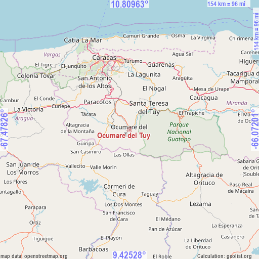
Ocumare del Tuy GPS coordinates[2]
10° 7' 5.52" North, 66° 46' 30.468" West
| Map corner | latitude | longitude |
|---|---|---|
| Upper-left | 10.80963°, | -67.47826° |
| Center: | 10.1182°, | -66.77513° |
| Lower-right: | 9.42528°, | -66.07201° |
| Map W x H: | 153.9×153.9 km | = 95.6×95.6mi |
| max Lat: | 11.94788° ⇑38.2% North |
| Ocumare del Tuy: | 10.1182° |
| min Lat: | ⇓61.8% South 1.92027° |
| min Long | Ocumare del Tuy | max Long |
| -72.55212° | -66.77513° | -60.99778° |
| W 74%⇐ | ⇒26% E |
Elevation
Elevation of Ocumare del Tuy is 184 m = 604 ft, and this is 196.6 m = 645 ft below average elevation for this country.
| Max E: |
2986 m = 9797 ft | 49.4% |
| Avg. | 380.6 m = 1249 ft | |
| Ocumare del Tuy | 184 m = 604 ft | |
Min E: |
-4 m = -13 ft | 50.6% |
See also: Ocumare del Tuy elevation on elevation.city.
Geographical zone
Ocumare del Tuy is located in North Torrid zone (between Equator and Tropic of Cancer). Distance of Equator is 1125 km =699 mi to South.| Distance of | km | miles | from Ocumare del Tuy |
|---|---|---|---|
| North Pole | 8882 | 5519 | to North |
| Arctic Circle | 6276.1 | 3899.8 | to North |
| Tropic Cancer | 1480.9 | 920.2 | to North |
| Equator | 1125 | 699 | to South |


Nearby cities:
15 places around Ocumare del Tuy: (largest is in red/bold)
• Baruta
36.8 km =22.9 mi,  342°
342°
• Camatagua
39.5 km =24.5 mi,  201°
201°
• Carrizal
34.6 km =21.5 mi,  318°
318°
• Caucaguita
26.8 km =16.7 mi,  353°
353°
• Charallave
16.5 km =10.3 mi,  326°
326°
• Cúa
12.7 km =7.9 mi,  292°
292°
• El Cafetal
39.1 km =24.3 mi, 351°
• El Hatillo
34.5 km =21.4 mi, 350°
• Los Teques
38.6 km =24 mi,  310°
310°
• Petare
40 km =24.9 mi, 354°
• San Antonio de Los Altos
35.7 km =22.2 mi, 327°
• San Casimiro
29.2 km =18.1 mi,  243°
243°
• San Francisco de Yare
7.3 km =4.5 mi,  25°
25°
• Santa Lucía
24.3 km =15.1 mi, 31°
• Santa Teresa del Tuy
17.6 km =10.9 mi,  43°
43°
In other languages:
- In Spanish: Ocumare, Ocumare del Tuy
- In France: Ocumare del Tuy, Ocumare
- In German: Ocumare
Sources, notices
• [Note1] Compared only with cities in Venezuela existing in our database
• [Src1] Map data: © OpenStreetMap contributors (CC-BY-SA)
• [Src2] Other city data from geonames.org with taken over terms of usage.
• [Src3] Geographical zone / Annual Mean Temperature by Robert A. Rohde @ Wikipedia
