Camatagua geodata
Camatagua (Aragua) is a seat of a second-order administrative division; located in Venezuela in America/Caracas (GMT-4) time zone. In our database, there are 108 cities with bigger population. Compared to other cities in Venezuela, 54.5% of cities are located further ↓South; 70.5% of cities are located further ←West and 60.3% of cities have lower elevation than Camatagua. Note1


Camatagua GPS coordinates[2]
9° 47' 15.432" North, 66° 54' 22.284" West
| Map corner | latitude | longitude |
|---|---|---|
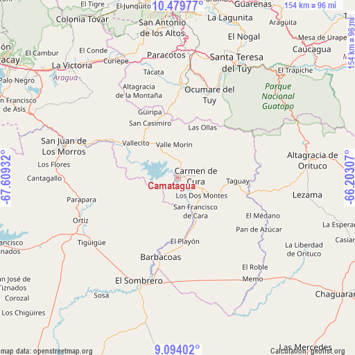
| Upper-left | 10.47977°, | -67.60932° |
| Center: | 9.78762°, | -66.90619° |
| Lower-right: | 9.09402°, | -66.20307° |
| Map W x H: | 154.1×154.1 km | = 95.8×95.8mi |
| max Lat: | 11.94788° ⇑45.5% North |
| Camatagua: | 9.78762° |
| min Lat: | ⇓54.5% South 1.92027° |
| min Long | Camatagua | max Long |
| -72.55212° | -66.90619° | -60.99778° |
| W 70.5%⇐ | ⇒29.5% E |
Elevation
Elevation of Camatagua is 250 m = 820 ft, and this is 130.6 m = 428 ft below average elevation for this country.
| Max E: |
2986 m = 9797 ft | 39.7% |
| Avg. | 380.6 m = 1249 ft | |
| Camatagua | 250 m = 820 ft | |
Min E: |
-4 m = -13 ft | 60.3% |
See also: Venezuela elevation on elevation.city.
Geographical zone
Camatagua is located in North Torrid zone (between Equator and Tropic of Cancer). Distance of Equator is 1088.3 km =676.2 mi to South.| Distance of | km | miles | from Camatagua |
|---|---|---|---|
| North Pole | 8918.8 | 5541.9 | to North |
| Arctic Circle | 6312.9 | 3922.7 | to North |
| Tropic Cancer | 1517.6 | 943 | to North |
| Equator | 1088.3 | 676.2 | to South |


Nearby cities:
15 places around Camatagua: (largest is in red/bold)
• Altagracia de Orituco
58.1 km =36.1 mi,  82°
82°
• Barbacoas
35.2 km =21.9 mi,  192°
192°
• Carrizal
63.1 km =39.2 mi,  352°
352°
• Charallave
50.9 km =31.6 mi,  6°
6°
• Cúa
41.8 km =26 mi,  3°
3°
• El Sombrero
47.6 km =29.6 mi,  200°
200°
• Las Tejerías
59.6 km =37 mi,  330°
330°
• Ocumare del Tuy
39.5 km =24.5 mi,  21°
21°
• Ortiz
46 km =28.6 mi,  246°
246°
• San Casimiro
26.6 km =16.5 mi, 333°
• San Francisco de Yare
46.8 km =29.1 mi, 21°
• San Juan de los Morros
50.9 km =31.6 mi,  285°
285°
• San Sebastián
33.7 km =20.9 mi,  300°
300°
• Santa Lucía
63.5 km =39.5 mi,  25°
25°
• Santa Teresa del Tuy
56.1 km =34.9 mi, 28°
Sources, notices
• [Note1] Compared only with cities in Venezuela existing in our database
• [Src1] Map data: © OpenStreetMap contributors (CC-BY-SA)
• [Src2] Other city data from geonames.org with taken over terms of usage.
• [Src3] Geographical zone / Annual Mean Temperature by Robert A. Rohde @ Wikipedia
