Bruzual geodata
Bruzual (Apure) is a seat of a second-order administrative division; located in Venezuela in America/Caracas (GMT-4) time zone. In our database, there are 108 cities with bigger population. Compared to other cities in Venezuela, 85.2% of cities are located further ↑North; 57% of cities are located further →East and 69.7% of cities have higher elevation than Bruzual. Note1


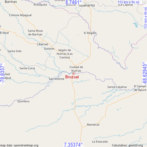
Bruzual GPS coordinates[2]
8° 3' 1.872" North, 69° 19' 57.252" West
| Map corner | latitude | longitude |
|---|---|---|
| Upper-left | 8.7461°, | -70.0357° |
| Center: | 8.05052°, | -69.33257° |
| Lower-right: | 7.35374°, | -68.62945° |
| Map W x H: | 154.8×154.8 km | = 96.2×96.2mi |
| max Lat: | 11.94788° ⇑85.2% North |
| Bruzual: | 8.05052° |
| min Lat: | ⇓14.8% South 1.92027° |
| min Long | Bruzual | max Long |
| -72.55212° | -69.33257° | -60.99778° |
| W 43%⇐ | ⇒57% E |
Elevation
Elevation of Bruzual is 85 m = 279 ft, and this is 295.6 m = 970 ft below average elevation for this country.
| Max E: |
2986 m = 9797 ft | 69.7% |
| Avg. | 380.6 m = 1249 ft | |
| Bruzual | 85 m = 279 ft | |
Min E: |
-4 m = -13 ft | 30.3% |
See also: Venezuela elevation on elevation.city.
Geographical zone
Bruzual is located in North Torrid zone (between Equator and Tropic of Cancer). Distance of Equator is 895.1 km =556.2 mi to South.| Distance of | km | miles | from Bruzual |
|---|---|---|---|
| North Pole | 9111.9 | 5661.9 | to North |
| Arctic Circle | 6506 | 4042.6 | to North |
| Tropic Cancer | 1710.8 | 1063 | to North |
| Equator | 895.1 | 556.2 | to South |


Nearby cities:
15 places around Bruzual: (largest is in red/bold)
• Arauquita
81.4 km =50.6 mi,  333°
333°
• Ciudad De Nutrias
5.7 km =3.5 mi,  28°
28°
• Dolores
36.7 km =22.8 mi,  315°
315°
• El Real
84.6 km =52.6 mi,  300°
300°
• El Regalo
46 km =28.6 mi,  21°
21°
• Guanarito
73.1 km =45.4 mi,  10°
10°
• La Luz
66.2 km =41.1 mi,  305°
305°
• Las Casitas del Vegon de Nutrias
22.8 km =14.2 mi,  335°
335°
• Libertad
45 km =28 mi, 313°
• Puerto de Nutrias
4.1 km =2.5 mi,  53°
53°
• San Rafael de Canaguá
74.5 km =46.3 mi,  267°
267°
• Santa Catalina
47.8 km =29.7 mi,  107°
107°
• Santa Inés
66.5 km =41.3 mi,  290°
290°
• Santa Lucía
49.3 km =30.6 mi,  276°
276°
• Santa Rosa
59.4 km =36.9 mi, 316°
Sources, notices
• [Note1] Compared only with cities in Venezuela existing in our database
• [Src1] Map data: © OpenStreetMap contributors (CC-BY-SA)
• [Src2] Other city data from geonames.org with taken over terms of usage.
• [Src3] Geographical zone / Annual Mean Temperature by Robert A. Rohde @ Wikipedia
