El Regalo geodata
El Regalo (Barinas) is a seat of a third-order administrative division; located in Venezuela in America/Caracas (GMT-4) time zone. In our database, there are 108 cities with bigger population. Compared to other cities in Venezuela, 76.1% of cities are located further ↑North; 54.2% of cities are located further →East and 69.2% of cities have higher elevation than El Regalo. Note1


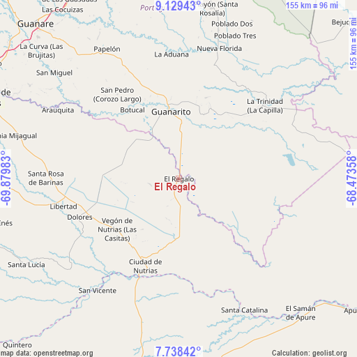
El Regalo GPS coordinates[2]
8° 26' 4.38" North, 69° 10' 36.12" West
| Map corner | latitude | longitude |
|---|---|---|
| Upper-left | 9.12943°, | -69.87983° |
| Center: | 8.43455°, | -69.1767° |
| Lower-right: | 7.73842°, | -68.47358° |
| Map W x H: | 154.7×154.7 km | = 96.1×96.1mi |
| max Lat: | 11.94788° ⇑76.1% North |
| El Regalo: | 8.43455° |
| min Lat: | ⇓23.9% South 1.92027° |
| min Long | El Regalo | max Long |
| -72.55212° | -69.1767° | -60.99778° |
| W 45.8%⇐ | ⇒54.2% E |
Elevation
Elevation of El Regalo is 86 m = 282 ft, and this is 294.6 m = 967 ft below average elevation for this country.
| Max E: |
2986 m = 9797 ft | 69.2% |
| Avg. | 380.6 m = 1249 ft | |
| El Regalo | 86 m = 282 ft | |
Min E: |
-4 m = -13 ft | 30.8% |
See also: Venezuela elevation on elevation.city.
Geographical zone
El Regalo is located in North Torrid zone (between Equator and Tropic of Cancer). Distance of Equator is 937.8 km =582.7 mi to South.| Distance of | km | miles | from El Regalo |
|---|---|---|---|
| North Pole | 9069.2 | 5635.3 | to North |
| Arctic Circle | 6463.3 | 4016.1 | to North |
| Tropic Cancer | 1668.1 | 1036.5 | to North |
| Equator | 937.8 | 582.7 | to South |


Nearby cities:
15 places around El Regalo: (largest is in red/bold)
• Arauquita
61 km =37.9 mi,  299°
299°
• Bruzual
46 km =28.6 mi,  201°
201°
• Ciudad De Nutrias
40.4 km =25.1 mi, 200°
• Dolores
45.9 km =28.5 mi,  248°
248°
• El Playón
75.4 km =46.9 mi,  11°
11°
• Guanarito
29.3 km =18.2 mi,  353°
353°
• La Luz
71.3 km =44.3 mi,  266°
266°
• Las Casitas del Vegon de Nutrias
34.5 km =21.4 mi,  230°
230°
• Libertad
51.4 km =31.9 mi,  256°
256°
• Papelón
64.4 km =40 mi,  331°
331°
• Puerto de Nutrias
42.5 km =26.4 mi, 198°
• Santa Catalina
63.5 km =39.5 mi,  153°
153°
• Santa Inés
81.6 km =50.7 mi, 256°
• Santa Lucía
75.8 km =47.1 mi,  240°
240°
• Santa Rosa
57.7 km =35.9 mi, 270°
Sources, notices
• [Note1] Compared only with cities in Venezuela existing in our database
• [Src1] Map data: © OpenStreetMap contributors (CC-BY-SA)
• [Src2] Other city data from geonames.org with taken over terms of usage.
• [Src3] Geographical zone / Annual Mean Temperature by Robert A. Rohde @ Wikipedia
