Cordero geodata
Cordero (Táchira) is a seat of a second-order administrative division; located in Venezuela in America/Caracas (GMT-4) time zone. In our database, there are 108 cities with bigger population. Compared to other cities in Venezuela, 90.1% of cities are located further ↑North; 95.2% of cities are located further →East and 93.6% of cities have lower elevation than Cordero. Note1


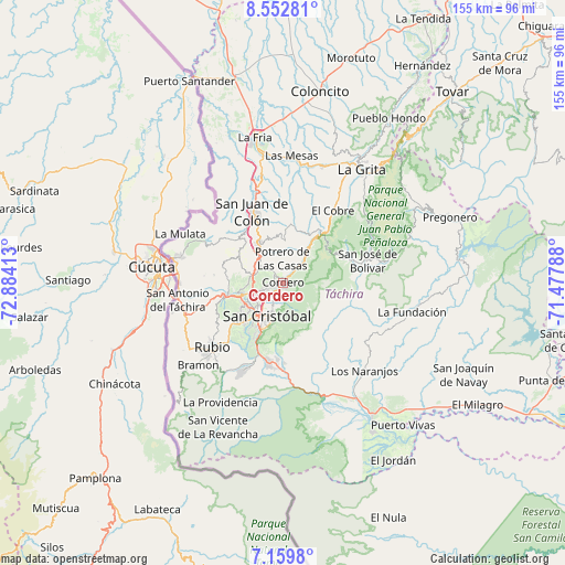
Cordero GPS coordinates[2]
7° 51' 24.804" North, 72° 10' 51.6" West
| Map corner | latitude | longitude |
|---|---|---|
| Upper-left | 8.55281°, | -72.88413° |
| Center: | 7.85689°, | -72.181° |
| Lower-right: | 7.1598°, | -71.47788° |
| Map W x H: | 154.9×154.9 km | = 96.3×96.3mi |
| max Lat: | 11.94788° ⇑90.1% North |
| Cordero: | 7.85689° |
| min Lat: | ⇓9.9% South 1.92027° |
| min Long | Cordero | max Long |
| -72.55212° | -72.181° | -60.99778° |
| W 4.8%⇐ | ⇒95.2% E |
Elevation
Elevation of Cordero is 1227 m = 4026 ft, and this is 846.4 m = 2777 ft above average elevation for this country.
| Max E: |
2986 m = 9797 ft | 6.4% |
| Cordero | 1227 m 4026 ft | |
| Avg. | 380.6 m = 1249 ft | |
Min E: |
-4 m = -13 ft | 93.6% |
See also: Venezuela elevation on elevation.city.
Geographical zone
Cordero is located in North Torrid zone (between Equator and Tropic of Cancer). Distance of Equator is 873.6 km =542.8 mi to South.| Distance of | km | miles | from Cordero |
|---|---|---|---|
| North Pole | 9133.5 | 5675.3 | to North |
| Arctic Circle | 6527.6 | 4056.1 | to North |
| Tropic Cancer | 1732.3 | 1076.4 | to North |
| Equator | 873.6 | 542.8 | to South |


Nearby cities:
15 places around Cordero: (largest is in red/bold)
• Capacho Nuevo
14.5 km =9 mi,  255°
255°
• Capacho Viejo
15.6 km =9.7 mi, 258°
• Colón
21.3 km =13.2 mi,  335°
335°
• El Cobre
24 km =14.9 mi,  34°
34°
• Lobatera
10.9 km =6.8 mi,  317°
317°
• Michelena
13 km =8.1 mi,  328°
328°
• Palmira
5.6 km =3.5 mi,  247°
247°
• Queniquea
19.6 km =12.2 mi,  70°
70°
• Rubio
25.9 km =16.1 mi,  228°
228°
• San Antonio del Táchira
29.3 km =18.2 mi, 260°
• San Cristóbal
11.1 km =6.9 mi,  205°
205°
• San Josecito
22.2 km =13.8 mi,  191°
191°
• San José de Bolívar
23.8 km =14.8 mi, 74°
• Santa Ana
26.1 km =16.2 mi,  203°
203°
• Táriba
6.4 km =4 mi, 228°
Sources, notices
• [Note1] Compared only with cities in Venezuela existing in our database
• [Src1] Map data: © OpenStreetMap contributors (CC-BY-SA)
• [Src2] Other city data from geonames.org with taken over terms of usage.
• [Src3] Geographical zone / Annual Mean Temperature by Robert A. Rohde @ Wikipedia
