San Cristóbal geodata
San Cristóbal (Táchira) is a seat of a first-order administrative division; located in Venezuela in America/Caracas (GMT-4) time zone. With population of 246,583 people, there are 17 cities with bigger population in this country. Compared to other cities in Venezuela, 92.4% of cities are located further ↑North; 95.9% of cities are located further →East and 86% of cities have lower elevation than San Cristóbal. Note1


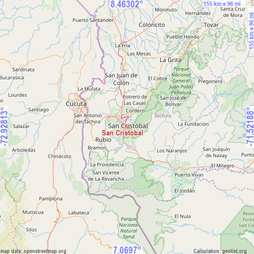
San Cristóbal GPS coordinates[2]
7° 46' 0.984" North, 72° 13' 30" West
| Map corner | latitude | longitude |
|---|---|---|
| Upper-left | 8.46302°, | -72.92813° |
| Center: | 7.76694°, | -72.225° |
| Lower-right: | 7.0697°, | -71.52188° |
| Map W x H: | 154.9×154.9 km | = 96.3×96.3mi |
| max Lat: | 11.94788° ⇑92.4% North |
| San Cristóbal: | 7.76694° |
| min Lat: | ⇓7.6% South 1.92027° |
| min Long | San Cristóbal | max Long |
| -72.55212° | -72.225° | -60.99778° |
| W 4.1%⇐ | ⇒95.9% E |
Elevation
Elevation of San Cristóbal is 899 m = 2949 ft, and this is 518.4 m = 1701 ft above average elevation for this country.
| Max E: |
2986 m = 9797 ft | 14% |
| San Cristóbal | 899 m 2949 ft | |
| Avg. | 380.6 m = 1249 ft | |
Min E: |
-4 m = -13 ft | 86% |
See also: San Cristóbal elevation on elevation.city.
Geographical zone
San Cristóbal is located in North Torrid zone (between Equator and Tropic of Cancer). Distance of Equator is 863.6 km =536.6 mi to South.| Distance of | km | miles | from San Cristóbal |
|---|---|---|---|
| North Pole | 9143.5 | 5681.5 | to North |
| Arctic Circle | 6537.6 | 4062.3 | to North |
| Tropic Cancer | 1742.3 | 1082.6 | to North |
| Equator | 863.6 | 536.6 | to South |


Nearby cities:
15 places around San Cristóbal: (largest is in red/bold)
• Capacho Nuevo
11.2 km =7 mi,  304°
304°
• Capacho Viejo
12.5 km =7.8 mi, 303°
• Colón
29.6 km =18.4 mi,  352°
352°
• Cordero
11.1 km =6.9 mi,  25°
25°
• Lobatera
18.3 km =11.4 mi, 352°
• Michelena
21.2 km =13.2 mi, 354°
• Palmira
7.8 km =4.8 mi,  357°
357°
• Queniquea
28.6 km =17.8 mi,  54°
54°
• Rubio
16.1 km =10 mi,  243°
243°
• San Antonio del Táchira
24.6 km =15.3 mi,  282°
282°
• San Josecito
11.8 km =7.3 mi,  177°
177°
• San José de Bolívar
32.2 km =20 mi,  59°
59°
• Santa Ana
15 km =9.3 mi,  202°
202°
• Táriba
5.8 km =3.6 mi,  0°
0°
• Ureña
29.7 km =18.5 mi, 304°
Sources, notices
• [Note1] Compared only with cities in Venezuela existing in our database
• [Src1] Map data: © OpenStreetMap contributors (CC-BY-SA)
• [Src2] Other city data from geonames.org with taken over terms of usage.
• [Src3] Geographical zone / Annual Mean Temperature by Robert A. Rohde @ Wikipedia
