Colón geodata
Colón (Táchira) is a seat of a second-order administrative division; located in Venezuela in America/Caracas (GMT-4) time zone. With population of 38,233 people, there are 88 cities with bigger population in this country. Compared to other cities in Venezuela, 86% of cities are located further ↑North; 97.5% of cities are located further →East and 82.7% of cities have lower elevation than Colón. Note1


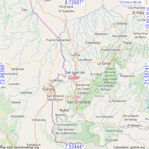
Colón GPS coordinates[2]
8° 1' 52.5" North, 72° 15' 37.908" West
| Map corner | latitude | longitude |
|---|---|---|
| Upper-left | 8.72687°, | -72.96366° |
| Center: | 8.03125°, | -72.26053° |
| Lower-right: | 7.33444°, | -71.55741° |
| Map W x H: | 154.8×154.8 km | = 96.2×96.2mi |
| max Lat: | 11.94788° ⇑86% North |
| Colón: | 8.03125° |
| min Lat: | ⇓14% South 1.92027° |
| min Long | Colón | max Long |
| -72.55212° | -72.26053° | -60.99778° |
| W 2.5%⇐ | ⇒97.5% E |
Elevation
Elevation of Colón is 805 m = 2641 ft, and this is 424.4 m = 1392 ft above average elevation for this country.
| Max E: |
2986 m = 9797 ft | 17.3% |
| Colón | 805 m 2641 ft | |
| Avg. | 380.6 m = 1249 ft | |
Min E: |
-4 m = -13 ft | 82.7% |
See also: Venezuela elevation on elevation.city.
Geographical zone
Colón is located in North Torrid zone (between Equator and Tropic of Cancer). Distance of Equator is 893 km =554.9 mi to South.| Distance of | km | miles | from Colón |
|---|---|---|---|
| North Pole | 9114.1 | 5663.2 | to North |
| Arctic Circle | 6508.2 | 4044 | to North |
| Tropic Cancer | 1712.9 | 1064.3 | to North |
| Equator | 893 | 554.9 | to South |


Nearby cities:
15 places around Colón: (largest is in red/bold)
• Capacho Nuevo
23.6 km =14.7 mi,  192°
192°
• Capacho Viejo
23.4 km =14.5 mi,  196°
196°
• Cordero
21.3 km =13.2 mi,  155°
155°
• El Cobre
22.4 km =13.9 mi,  88°
88°
• La Fría
20.5 km =12.7 mi,  3°
3°
• Las Mesas
19.1 km =11.9 mi,  35°
35°
• Lobatera
11.4 km =7.1 mi,  172°
172°
• Michelena
8.5 km =5.3 mi, 166°
• Palmira
21.9 km =13.6 mi, 170°
• Queniquea
30 km =18.6 mi,  115°
115°
• San Cristóbal
29.6 km =18.4 mi, 172°
• Santa Ana
28 km =17.4 mi,  70°
70°
• Seboruco
24.2 km =15 mi,  58°
58°
• Táriba
24 km =14.9 mi, 170°
• Ureña
24.1 km =15 mi,  238°
238°
Sources, notices
• [Note1] Compared only with cities in Venezuela existing in our database
• [Src1] Map data: © OpenStreetMap contributors (CC-BY-SA)
• [Src2] Other city data from geonames.org with taken over terms of usage.
• [Src3] Geographical zone / Annual Mean Temperature by Robert A. Rohde @ Wikipedia
