Rubio geodata
Rubio (Táchira) is a seat of a second-order administrative division; located in Venezuela in America/Caracas (GMT-4) time zone. With population of 51,568 people, there are 75 cities with bigger population in this country. Compared to other cities in Venezuela, 93.1% of cities are located further ↑North; 98.7% of cities are located further →East and 83.2% of cities have lower elevation than Rubio. Note1


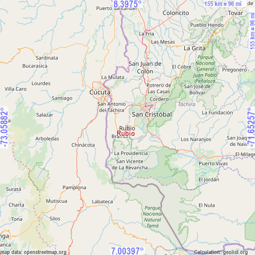
Rubio GPS coordinates[2]
7° 42' 4.716" North, 72° 21' 20.484" West
| Map corner | latitude | longitude |
|---|---|---|
| Upper-left | 8.3975°, | -73.05882° |
| Center: | 7.70131°, | -72.35569° |
| Lower-right: | 7.00397°, | -71.65257° |
| Map W x H: | 154.9×154.9 km | = 96.3×96.3mi |
| max Lat: | 11.94788° ⇑93.1% North |
| Rubio: | 7.70131° |
| min Lat: | ⇓6.9% South 1.92027° |
| min Long | Rubio | max Long |
| -72.55212° | -72.35569° | -60.99778° |
| W 1.3%⇐ | ⇒98.7% E |
Elevation
Elevation of Rubio is 833 m = 2733 ft, and this is 452.4 m = 1484 ft above average elevation for this country.
| Max E: |
2986 m = 9797 ft | 16.8% |
| Rubio | 833 m 2733 ft | |
| Avg. | 380.6 m = 1249 ft | |
Min E: |
-4 m = -13 ft | 83.2% |
See also: Rubio elevation on elevation.city.
Geographical zone
Rubio is located in North Torrid zone (between Equator and Tropic of Cancer). Distance of Equator is 856.3 km =532.1 mi to South.| Distance of | km | miles | from Rubio |
|---|---|---|---|
| North Pole | 9150.8 | 5686 | to North |
| Arctic Circle | 6544.9 | 4066.8 | to North |
| Tropic Cancer | 1749.6 | 1087.2 | to North |
| Equator | 856.3 | 532.1 | to South |


Nearby cities:
15 places around Rubio: (largest is in red/bold)
• Capacho Nuevo
14.7 km =9.1 mi,  20°
20°
• Capacho Viejo
14.7 km =9.1 mi, 15°
• Colón
38.2 km =23.7 mi, 15°
• Cordero
25.9 km =16.1 mi,  48°
48°
• Delicias
18.2 km =11.3 mi,  213°
213°
• Lobatera
28.1 km =17.5 mi,  25°
25°
• Michelena
31 km =19.3 mi, 23°
• Palmira
20.7 km =12.9 mi,  42°
42°
• Queniquea
44.6 km =27.7 mi,  57°
57°
• San Antonio del Táchira
15.9 km =9.9 mi,  322°
322°
• San Cristóbal
16.1 km =10 mi, 63°
• San Josecito
15.6 km =9.7 mi,  106°
106°
• Santa Ana
10.9 km =6.8 mi,  127°
127°
• Táriba
19.5 km =12.1 mi, 47°
• Ureña
26.2 km =16.3 mi,  337°
337°
Sources, notices
• [Note1] Compared only with cities in Venezuela existing in our database
• [Src1] Map data: © OpenStreetMap contributors (CC-BY-SA)
• [Src2] Other city data from geonames.org with taken over terms of usage.
• [Src3] Geographical zone / Annual Mean Temperature by Robert A. Rohde @ Wikipedia
