Thị Trấn Giá Rai geodata
Thị Trấn Giá Rai (Bạc Liêu) is a seat of a second-order administrative division; located in Vietnam in Asia/Ho_Chi_Minh (GMT+7) time zone. In our database, there are 94 cities with bigger population. Compared to other cities in Vietnam, 98.5% of cities are located further ↑North; 78.3% of cities are located further →East and 92.5% of cities have higher elevation than Thị Trấn Giá Rai. Note1


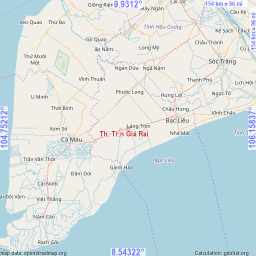
Thị Trấn Giá Rai GPS coordinates[2]
9° 14' 16.404" North, 105° 27' 18.864" East
| Map corner | latitude | longitude |
|---|---|---|
| Upper-left | 9.9312°, | 104.75212° |
| Center: | 9.23789°, | 105.45524° |
| Lower-right: | 8.54322°, | 106.15837° |
| Map W x H: | 154.3×154.3 km | = 95.9×95.9mi |
| max Lat: | 23.27841° ⇑98.5% North |
| Thị Trấn Giá Rai: | 9.23789° |
| min Lat: | ⇓1.5% South 8.65724° |
| min Long | Thị Trấn Gi | max Long |
| 102.4579° | 105.45524° | 112.72541° |
| W 21.7%⇐ | ⇒78.3% E |
Elevation
Elevation of Thị Trấn Giá Rai is 4 m = 13 ft, and this is 125.5 m = 412 ft below average elevation for this country.
| Max E: |
1592 m = 5223 ft | 92.5% |
| Avg. | 129.5 m = 425 ft | |
| Thị Trấn Giá Rai | 4 m = 13 ft | |
Min E: |
-1 m = -3 ft | 7.5% |
See also: Vietnam elevation on elevation.city.
Geographical zone
Thị Trấn Giá Rai is located in North Torrid zone (between Equator and Tropic of Cancer). Distance of Equator is 1027.2 km =638.3 mi to South.| Distance of | km | miles | from Thị Trấn Giá Rai |
|---|---|---|---|
| North Pole | 8979.9 | 5579.8 | to North |
| Arctic Circle | 6374 | 3960.6 | to North |
| Tropic Cancer | 1578.8 | 981 | to North |
| Equator | 1027.2 | 638.3 | to South |


Nearby cities:
15 places around Thị Trấn Giá Rai: (largest is in red/bold)
• Bạc Liêu
30.6 km =19 mi,  78°
78°
• Cà Mau
33.9 km =21.1 mi,  258°
258°
• Long Mỹ
51 km =31.7 mi,  14°
14°
• Nàng Mau
57.7 km =35.9 mi, 8°
• Phú Lộc
37.8 km =23.5 mi,  55°
55°
• Thị Trấn Gành Hào
23.2 km =14.4 mi,  189°
189°
• Thị Trấn Hòa Bình
19.8 km =12.3 mi,  74°
74°
• Thị Trấn Ngan Dừa
36.6 km =22.7 mi,  359°
359°
• Thị Trấn Phước Long
22.2 km =13.8 mi,  1°
1°
• Thới Bình
41.2 km =25.6 mi,  288°
288°
• Trần Văn Thời
55.2 km =34.3 mi,  251°
251°
• U Minh
56.3 km =35 mi, 290°
• Vĩnh Châu
58.4 km =36.3 mi, 80°
• Vĩnh Thuận
37.1 km =23.1 mi,  324°
324°
• Đầm Dơi
39.5 km =24.5 mi,  226°
226°
Sources, notices
• [Note1] Compared only with cities in Vietnam existing in our database
• [Src1] Map data: © OpenStreetMap contributors (CC-BY-SA)
• [Src2] Other city data from geonames.org with taken over terms of usage.
• [Src3] Geographical zone / Annual Mean Temperature by Robert A. Rohde @ Wikipedia
