Nàng Mau geodata
Nàng Mau (Hậu Giang) is a seat of a second-order administrative division; located in Vietnam in Asia/Ho_Chi_Minh (GMT+7) time zone. In our database, there are 94 cities with bigger population. Compared to other cities in Vietnam, 95.1% of cities are located further ↑North; 75.4% of cities are located further →East and 80.8% of cities have higher elevation than Nàng Mau. Note1


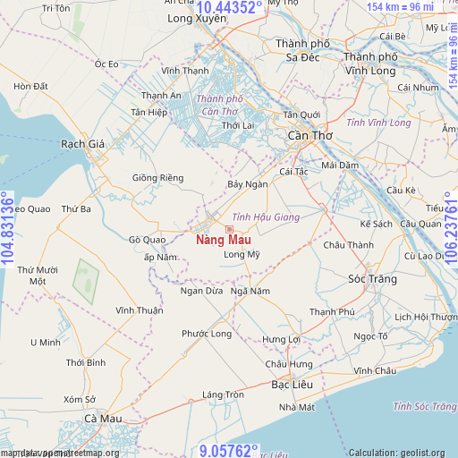
Nàng Mau GPS coordinates[2]
9° 45' 4.644" North, 105° 32' 4.128" East
| Map corner | latitude | longitude |
|---|---|---|
| Upper-left | 10.44352°, | 104.83136° |
| Center: | 9.75129°, | 105.53448° |
| Lower-right: | 9.05762°, | 106.23761° |
| Map W x H: | 154.1×154.1 km | = 95.8×95.8mi |
| max Lat: | 23.27841° ⇑95.1% North |
| Nàng Mau: | 9.75129° |
| min Lat: | ⇓4.9% South 8.65724° |
| min Long | Nàng Mau | max Long |
| 102.4579° | 105.53448° | 112.72541° |
| W 24.6%⇐ | ⇒75.4% E |
Elevation
Elevation of Nàng Mau is 6 m = 20 ft, and this is 123.5 m = 405 ft below average elevation for this country.
| Max E: |
1592 m = 5223 ft | 80.8% |
| Avg. | 129.5 m = 425 ft | |
| Nàng Mau | 6 m = 20 ft | |
Min E: |
-1 m = -3 ft | 19.2% |
See also: Vietnam elevation on elevation.city.
Geographical zone
Nàng Mau is located in North Torrid zone (between Equator and Tropic of Cancer). Distance of Equator is 1084.2 km =673.7 mi to South.| Distance of | km | miles | from Nàng Mau |
|---|---|---|---|
| North Pole | 8922.8 | 5544.4 | to North |
| Arctic Circle | 6316.9 | 3925.1 | to North |
| Tropic Cancer | 1521.7 | 945.5 | to North |
| Equator | 1084.2 | 673.7 | to South |


Nearby cities:
15 places around Nàng Mau: (largest is in red/bold)
• Cái Răng
36.5 km =22.7 mi,  40°
40°
• Cờ Đỏ
39.8 km =24.7 mi,  343°
343°
• Giồng Riềng
29.9 km =18.6 mi,  306°
306°
• Gò Quao
28.6 km =17.8 mi,  265°
265°
• Huỳnh Hữu Nghĩa
33 km =20.5 mi,  112°
112°
• Long Mỹ
8.8 km =5.5 mi,  151°
151°
• Một Ngàn
21.9 km =13.6 mi,  28°
28°
• Ngã Bảy
32.1 km =19.9 mi,  77°
77°
• Ngã Sáu
35.3 km =21.9 mi,  57°
57°
• Phong Điền
31 km =19.3 mi, 27°
• Phụng Hiệp
22.1 km =13.7 mi, 81°
• Thị Trấn Ngan Dừa
22.5 km =14 mi,  204°
204°
• Thị Trấn Phước Long
35.8 km =22.2 mi,  192°
192°
• Thới Lai
35 km =21.7 mi,  4°
4°
• Vị Thanh
8 km =5 mi,  297°
297°
Sources, notices
• [Note1] Compared only with cities in Vietnam existing in our database
• [Src1] Map data: © OpenStreetMap contributors (CC-BY-SA)
• [Src2] Other city data from geonames.org with taken over terms of usage.
• [Src3] Geographical zone / Annual Mean Temperature by Robert A. Rohde @ Wikipedia
