Vĩnh Thuận geodata
Vĩnh Thuận (Kiến Giang) is a seat of a second-order administrative division; located in Vietnam in Asia/Ho_Chi_Minh (GMT+7) time zone. In our database, there are 94 cities with bigger population. Compared to other cities in Vietnam, 97.2% of cities are located further ↑North; 84.3% of cities are located further →East and 95.4% of cities have higher elevation than Vĩnh Thuận. Note1


Vĩnh Thuận GPS coordinates[2]
9° 30' 28.872" North, 105° 15' 26.892" East
| Map corner | latitude | longitude |
|---|---|---|
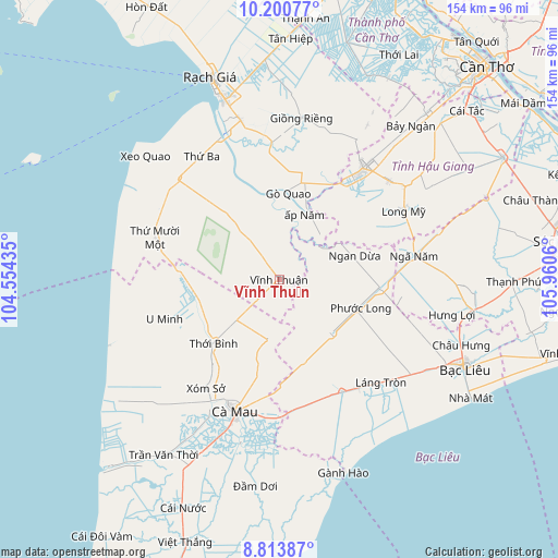
| Upper-left | 10.20077°, | 104.55435° |
| Center: | 9.50802°, | 105.25747° |
| Lower-right: | 8.81387°, | 105.9606° |
| Map W x H: | 154.2×154.2 km | = 95.8×95.8mi |
| max Lat: | 23.27841° ⇑97.2% North |
| Vĩnh Thuận: | 9.50802° |
| min Lat: | ⇓2.8% South 8.65724° |
| min Long | Vĩnh Thuận | max Long |
| 102.4579° | 105.25747° | 112.72541° |
| W 15.7%⇐ | ⇒84.3% E |
Elevation
Elevation of Vĩnh Thuận is 3 m = 10 ft, and this is 126.5 m = 415 ft below average elevation for this country.
| Max E: |
1592 m = 5223 ft | 95.4% |
| Avg. | 129.5 m = 425 ft | |
| Vĩnh Thuận | 3 m = 10 ft | |
Min E: |
-1 m = -3 ft | 4.6% |
See also: Vietnam elevation on elevation.city.
Geographical zone
Vĩnh Thuận is located in North Torrid zone (between Equator and Tropic of Cancer). Distance of Equator is 1057.2 km =656.9 mi to South.| Distance of | km | miles | from Vĩnh Thuận |
|---|---|---|---|
| North Pole | 8949.9 | 5561.2 | to North |
| Arctic Circle | 6344 | 3942 | to North |
| Tropic Cancer | 1548.7 | 962.3 | to North |
| Equator | 1057.2 | 656.9 | to South |


Nearby cities:
15 places around Vĩnh Thuận: (largest is in red/bold)
• An Biên
40.2 km =25 mi,  328°
328°
• Cà Mau
38.6 km =24 mi,  197°
197°
• Giồng Riềng
45.1 km =28 mi,  7°
7°
• Gò Quao
25.1 km =15.6 mi,  4°
4°
• Long Mỹ
39.5 km =24.5 mi,  60°
60°
• Minh Lương
45.2 km =28.1 mi,  346°
346°
• Nàng Mau
40.7 km =25.3 mi,  48°
48°
• Thị Trấn Giá Rai
37.1 km =23.1 mi,  144°
144°
• Thị Trấn Hòa Bình
47.7 km =29.6 mi,  121°
121°
• Thị Trấn Ngan Dừa
22.1 km =13.7 mi,  72°
72°
• Thị Trấn Phước Long
23.8 km =14.8 mi,  109°
109°
• Thới Bình
24.2 km =15 mi,  225°
225°
• Thứ Mười Một
36 km =22.4 mi,  288°
288°
• U Minh
32.9 km =20.4 mi,  251°
251°
• Vị Thanh
38.6 km =24 mi,  37°
37°
Sources, notices
• [Note1] Compared only with cities in Vietnam existing in our database
• [Src1] Map data: © OpenStreetMap contributors (CC-BY-SA)
• [Src2] Other city data from geonames.org with taken over terms of usage.
• [Src3] Geographical zone / Annual Mean Temperature by Robert A. Rohde @ Wikipedia
