Thị Trấn Tủa Chùa geodata
Thị Trấn Tủa Chùa (Ðiện Biên) is a seat of a second-order administrative division; located in Vietnam in Asia/Ho_Chi_Minh (GMT+7) time zone. In our database, there are 94 cities with bigger population. Compared to other cities in Vietnam, 89.6% of cities are located further ↓South; 98.5% of cities are located further →East and 97.1% of cities have lower elevation than Thị Trấn Tủa Chùa. Note1


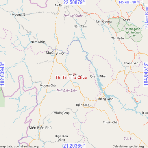
Thị Trấn Tủa Chùa GPS coordinates[2]
21° 51' 27.756" North, 103° 20' 33.36" East
| Map corner | latitude | longitude |
|---|---|---|
| Upper-left | 22.50879°, | 102.63948° |
| Center: | 21.85771°, | 103.3426° |
| Lower-right: | 21.20365°, | 104.04573° |
| Map W x H: | 145.1×145.1 km | = 90.2×90.2mi |
| max Lat: | 23.27841° ⇑10.4% North |
| Thị Trấn Tủa Chùa: | 21.85771° |
| min Lat: | ⇓89.6% South 8.65724° |
| min Long | Thị Trấn T� | max Long |
| 102.4579° | 103.3426° | 112.72541° |
| W 1.5%⇐ | ⇒98.5% E |
Elevation
Elevation of Thị Trấn Tủa Chùa is 862 m = 2828 ft, and this is 732.5 m = 2403 ft above average elevation for this country.
| Max E: |
1592 m = 5223 ft | 2.9% |
| Thị Trấn Tủa Chùa | 862 m 2828 ft | |
| Avg. | 129.5 m = 425 ft | |
Min E: |
-1 m = -3 ft | 97.1% |
See also: Vietnam elevation on elevation.city.
Geographical zone
Thị Trấn Tủa Chùa is located in North Torrid zone (between Equator and Tropic of Cancer). Distance of this Northern Tropic circle is 175.6 km =109.1 mi to North.| Distance of | km | miles | from Thị Trấn Tủa Chùa |
|---|---|---|---|
| North Pole | 7576.7 | 4707.9 | to North |
| Arctic Circle | 4970.8 | 3088.7 | to North |
| Tropic Cancer | 175.6 | 109.1 | to North |
| Equator | 2430.3 | 1510.1 | to South |


Nearby cities:
15 places around Thị Trấn Tủa Chùa: (largest is in red/bold)
• Cát Cát
72.3 km =44.9 mi,  43°
43°
• Dien Bien Phu
62 km =38.5 mi,  212°
212°
• Lai Châu
61.1 km =38 mi,  11°
11°
• Lao Chải
74.2 km =46.1 mi,  46°
46°
• Mường Chiên
23.1 km =14.4 mi,  94°
94°
• Mường Chà
27.4 km =17 mi,  247°
247°
• Mường Ảng
39.5 km =24.5 mi,  198°
198°
• Sa Pa
74.5 km =46.3 mi, 43°
• Tam Đường
58.9 km =36.6 mi,  29°
29°
• Than Uyên
56.6 km =35.2 mi,  78°
78°
• Thị Trấn Sìn Hồ
57.7 km =35.9 mi,  348°
348°
• Thị Trấn Thuận Châu
58.8 km =36.5 mi,  142°
142°
• Thị Trấn Tuần Giáo
30.9 km =19.2 mi,  164°
164°
• Thị Trấn Điện Biên
73.7 km =45.8 mi, 205°
• Điện Biên Đông
63.6 km =39.5 mi,  191°
191°
Sources, notices
• [Note1] Compared only with cities in Vietnam existing in our database
• [Src1] Map data: © OpenStreetMap contributors (CC-BY-SA)
• [Src2] Other city data from geonames.org with taken over terms of usage.
• [Src3] Geographical zone / Annual Mean Temperature by Robert A. Rohde @ Wikipedia
