Sa Pa geodata
Sa Pa (Lào Cai) is a populated place; located in Vietnam in Asia/Ho_Chi_Minh (GMT+7) time zone. With population of 10,554 people, there are 88 cities with bigger population in this country. Compared to other cities in Vietnam, 93.8% of cities are located further ↓South; 97.2% of cities are located further →East and 99.8% of cities have lower elevation than Sa Pa. Note1


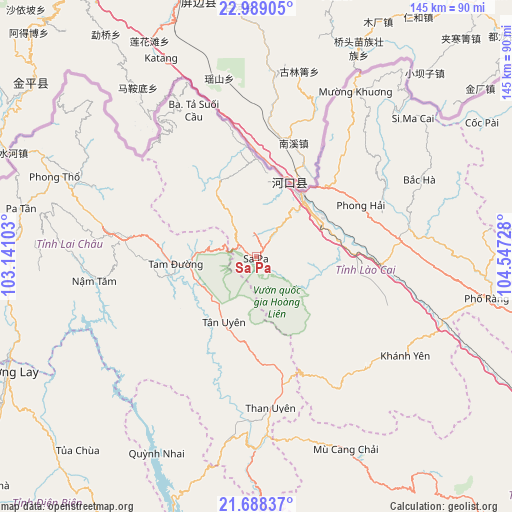
Sa Pa GPS coordinates[2]
22° 20' 24.828" North, 103° 50' 38.94" East
| Map corner | latitude | longitude |
|---|---|---|
| Upper-left | 22.98905°, | 103.14103° |
| Center: | 22.34023°, | 103.84415° |
| Lower-right: | 21.68837°, | 104.54728° |
| Map W x H: | 144.6×144.6 km | = 89.9×89.9mi |
| max Lat: | 23.27841° ⇑6.2% North |
| Sa Pa: | 22.34023° |
| min Lat: | ⇓93.8% South 8.65724° |
| min Long | Sa Pa | max Long |
| 102.4579° | 103.84415° | 112.72541° |
| W 2.8%⇐ | ⇒97.2% E |
Elevation
Elevation of Sa Pa is 1522 m = 4993 ft, and this is 1392.5 m = 4569 ft above average elevation for this country.
| Max E: |
1592 m = 5223 ft | 0.2% |
| Sa Pa | 1522 m 4993 ft | |
| Avg. | 129.5 m = 425 ft | |
Min E: |
-1 m = -3 ft | 99.8% |
See also: Vietnam elevation on elevation.city.
Geographical zone
Sa Pa is located in North Torrid zone (between Equator and Tropic of Cancer). Distance of this Northern Tropic circle is 121.9 km =75.7 mi to North.| Distance of | km | miles | from Sa Pa |
|---|---|---|---|
| North Pole | 7523.1 | 4674.6 | to North |
| Arctic Circle | 4917.2 | 3055.4 | to North |
| Tropic Cancer | 121.9 | 75.7 | to North |
| Equator | 2484 | 1543.5 | to South |


Nearby cities:
15 places around Sa Pa: (largest is in red/bold)
• Bát Xát
23 km =14.3 mi,  11°
11°
• Bắc Hà
51.2 km =31.8 mi,  64°
64°
• Cát Cát
2.3 km =1.4 mi,  241°
241°
• Lai Châu
40.2 km =25 mi,  278°
278°
• Lao Chải
3.9 km =2.4 mi,  139°
139°
• Lào Cai
20.7 km =12.9 mi,  38°
38°
• Mù Cang Chải
60 km =37.3 mi,  155°
155°
• Mường Chiên
62.3 km =38.7 mi,  207°
207°
• Phong Thổ
60.6 km =37.7 mi,  292°
292°
• Si Ma Cai
59.6 km =37 mi,  48°
48°
• Tam Đường
22.6 km =14 mi,  263°
263°
• Than Uyên
42.5 km =26.4 mi,  175°
175°
• Thị Trấn Khánh Yên
50.4 km =31.3 mi,  123°
123°
• Thị Trấn Mường Khương
54.8 km =34.1 mi,  31°
31°
• Thị Trấn Phố Lu
35.4 km =22 mi,  93°
93°
Sources, notices
• [Note1] Compared only with cities in Vietnam existing in our database
• [Src1] Map data: © OpenStreetMap contributors (CC-BY-SA)
• [Src2] Other city data from geonames.org with taken over terms of usage.
• [Src3] Geographical zone / Annual Mean Temperature by Robert A. Rohde @ Wikipedia
