Hòa Bình geodata
Hòa Bình is a seat of a first-order administrative division; located in Vietnam in Asia/Ho_Chi_Minh (GMT+7) time zone. With population of 105,260 people, there are 34 cities with bigger population in this country. Compared to other cities in Vietnam, 69% of cities are located further ↓South; 81.9% of cities are located further →East and 63.6% of cities have lower elevation than Hòa Bình. Note1


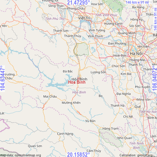
Hòa Bình GPS coordinates[2]
20° 49' 1.812" North, 105° 20' 15.324" East
| Map corner | latitude | longitude |
|---|---|---|
| Upper-left | 21.47295°, | 104.63447° |
| Center: | 20.81717°, | 105.33759° |
| Lower-right: | 20.15852°, | 106.04072° |
| Map W x H: | 146.2×146.2 km | = 90.8×90.8mi |
| max Lat: | 23.27841° ⇑31% North |
| Hòa Bình: | 20.81717° |
| min Lat: | ⇓69% South 8.65724° |
| min Long | Hòa Bình | max Long |
| 102.4579° | 105.33759° | 112.72541° |
| W 18.1%⇐ | ⇒81.9% E |
Elevation
Elevation of Hòa Bình is 31 m = 102 ft, and this is 98.5 m = 323 ft below average elevation for this country.
| Max E: |
1592 m = 5223 ft | 36.4% |
| Avg. | 129.5 m = 425 ft | |
| Hòa Bình | 31 m = 102 ft | |
Min E: |
-1 m = -3 ft | 63.6% |
See also: Hòa Bình elevation on elevation.city.
Geographical zone
Hòa Bình is located in North Torrid zone (between Equator and Tropic of Cancer). Distance of this Northern Tropic circle is 291.3 km =181 mi to North.| Distance of | km | miles | from Hòa Bình |
|---|---|---|---|
| North Pole | 7692.4 | 4779.8 | to North |
| Arctic Circle | 5086.5 | 3160.6 | to North |
| Tropic Cancer | 291.3 | 181 | to North |
| Equator | 2314.7 | 1438.3 | to South |


Nearby cities:
15 places around Hòa Bình: (largest is in red/bold)
• Bo
26.2 km =16.3 mi,  127°
127°
• Cao Phong
12.7 km =7.9 mi,  188°
188°
• Chúc Sơn
39.6 km =24.6 mi,  72°
72°
• Kỳ Sơn
7.9 km =4.9 mi,  11°
11°
• Liên Quan
36.6 km =22.7 mi,  43°
43°
• Lương Sơn
20.5 km =12.7 mi, 72°
• Mường Khến
23.3 km =14.5 mi,  195°
195°
• Phúc Thọ
38.5 km =23.9 mi,  34°
34°
• Quốc Oai
36.9 km =22.9 mi,  58°
58°
• Sơn Tây
40 km =24.9 mi, 26°
• Thanh Thủy
40.2 km =25 mi,  352°
352°
• Tây Đằng
43.3 km =26.9 mi, 11°
• Vụ Bản
40.8 km =25.4 mi,  164°
164°
• Đà Bắc
10.9 km =6.8 mi,  307°
307°
• Đại Nghĩa
44.7 km =27.8 mi,  108°
108°
Sources, notices
• [Note1] Compared only with cities in Vietnam existing in our database
• [Src1] Map data: © OpenStreetMap contributors (CC-BY-SA)
• [Src2] Other city data from geonames.org with taken over terms of usage.
• [Src3] Geographical zone / Annual Mean Temperature by Robert A. Rohde @ Wikipedia
