Sơn Tây geodata
Sơn Tây (Hanoi) is a seat of a second-order administrative division; located in Vietnam in Asia/Ho_Chi_Minh (GMT+7) time zone. With population of 40,636 people, there are 63 cities with bigger population in this country. Compared to other cities in Vietnam, 78.3% of cities are located further ↓South; 76.3% of cities are located further →East and 53.3% of cities have lower elevation than Sơn Tây. Note1


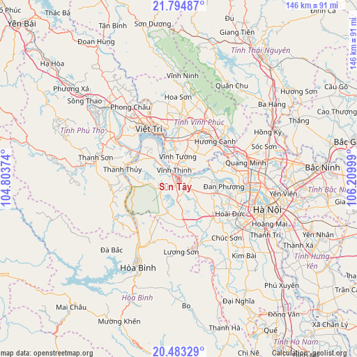
Sơn Tây GPS coordinates[2]
21° 8' 25.908" North, 105° 30' 24.696" East
| Map corner | latitude | longitude |
|---|---|---|
| Upper-left | 21.79487°, | 104.80374° |
| Center: | 21.14053°, | 105.50686° |
| Lower-right: | 20.48329°, | 106.20999° |
| Map W x H: | 145.8×145.8 km | = 90.6×90.6mi |
| max Lat: | 23.27841° ⇑21.7% North |
| Sơn Tây: | 21.14053° |
| min Lat: | ⇓78.3% South 8.65724° |
| min Long | Sơn Tây | max Long |
| 102.4579° | 105.50686° | 112.72541° |
| W 23.7%⇐ | ⇒76.3% E |
Elevation
Elevation of Sơn Tây is 16 m = 52 ft, and this is 113.5 m = 372 ft below average elevation for this country.
| Max E: |
1592 m = 5223 ft | 46.7% |
| Avg. | 129.5 m = 425 ft | |
| Sơn Tây | 16 m = 52 ft | |
Min E: |
-1 m = -3 ft | 53.3% |
See also: Sơn Tây elevation on elevation.city.
Geographical zone
Sơn Tây is located in North Torrid zone (between Equator and Tropic of Cancer). Distance of this Northern Tropic circle is 255.3 km =158.6 mi to North.| Distance of | km | miles | from Sơn Tây |
|---|---|---|---|
| North Pole | 7656.5 | 4757.5 | to North |
| Arctic Circle | 5050.6 | 3138.3 | to North |
| Tropic Cancer | 255.3 | 158.6 | to North |
| Equator | 2350.6 | 1460.6 | to South |


Nearby cities:
15 places around Sơn Tây: (largest is in red/bold)
• Hưng Hóa
25.4 km =15.8 mi,  300°
300°
• Hương Canh
21.2 km =13.2 mi,  43°
43°
• Liên Quan
11.9 km =7.4 mi,  140°
140°
• Mê Linh
22.6 km =14 mi,  77°
77°
• Phùng
16.8 km =10.4 mi,  109°
109°
• Phúc Thọ
5.8 km =3.6 mi, 135°
• Phúc Yên
23.2 km =14.4 mi,  62°
62°
• Quốc Oai
21.7 km =13.5 mi, 140°
• Thanh Thủy
23.4 km =14.5 mi,  279°
279°
• Trôi
22.2 km =13.8 mi, 110°
• Tây Đằng
10.9 km =6.8 mi,  306°
306°
• Việt Trì
23 km =14.3 mi,  331°
331°
• Vĩnh Tường
8.5 km =5.3 mi,  3°
3°
• Vĩnh Yên
21.3 km =13.2 mi,  28°
28°
• Yên Lạc
12.7 km =7.9 mi, 32°
Sources, notices
• [Note1] Compared only with cities in Vietnam existing in our database
• [Src1] Map data: © OpenStreetMap contributors (CC-BY-SA)
• [Src2] Other city data from geonames.org with taken over terms of usage.
• [Src3] Geographical zone / Annual Mean Temperature by Robert A. Rohde @ Wikipedia
