Phúc Yên geodata
Phúc Yên (Vĩnh Phúc) is a seat of a second-order administrative division; located in Vietnam in Asia/Ho_Chi_Minh (GMT+7) time zone. In our database, there are 94 cities with bigger population. Compared to other cities in Vietnam, 80.6% of cities are located further ↓South; 68% of cities are located further →East and 57.9% of cities have lower elevation than Phúc Yên. Note1


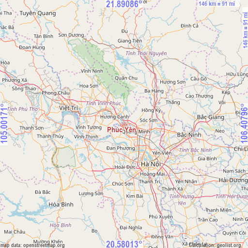
Phúc Yên GPS coordinates[2]
21° 14' 13.02" North, 105° 42' 17.388" East
| Map corner | latitude | longitude |
|---|---|---|
| Upper-left | 21.89086°, | 105.00171° |
| Center: | 21.23695°, | 105.70483° |
| Lower-right: | 20.58013°, | 106.40796° |
| Map W x H: | 145.7×145.7 km | = 90.5×90.5mi |
| max Lat: | 23.27841° ⇑19.4% North |
| Phúc Yên: | 21.23695° |
| min Lat: | ⇓80.6% South 8.65724° |
| min Long | Phúc Yên | max Long |
| 102.4579° | 105.70483° | 112.72541° |
| W 32%⇐ | ⇒68% E |
Elevation
Elevation of Phúc Yên is 20 m = 66 ft, and this is 109.5 m = 359 ft below average elevation for this country.
| Max E: |
1592 m = 5223 ft | 42.1% |
| Avg. | 129.5 m = 425 ft | |
| Phúc Yên | 20 m = 66 ft | |
Min E: |
-1 m = -3 ft | 57.9% |
See also: Vietnam elevation on elevation.city.
Geographical zone
Phúc Yên is located in North Torrid zone (between Equator and Tropic of Cancer). Distance of this Northern Tropic circle is 244.6 km =152 mi to North.| Distance of | km | miles | from Phúc Yên |
|---|---|---|---|
| North Pole | 7645.7 | 4750.8 | to North |
| Arctic Circle | 5039.8 | 3131.6 | to North |
| Tropic Cancer | 244.6 | 152 | to North |
| Equator | 2361.3 | 1467.2 | to South |


Nearby cities:
15 places around Phúc Yên: (largest is in red/bold)
• Cầu Diễn
22.9 km =14.2 mi,  163°
163°
• Hương Canh
7.6 km =4.7 mi,  307°
307°
• Hợp Hòa
22.8 km =14.2 mi, 312°
• Mê Linh
6.2 km =3.9 mi, 164°
• Phùng
17.1 km =10.6 mi,  196°
196°
• Phúc Thọ
22.2 km =13.8 mi,  228°
228°
• Sóc Sơn
15.1 km =9.4 mi,  81°
81°
• Sơn Tây
23.2 km =14.4 mi,  242°
242°
• Trai Ngau
19.7 km =12.2 mi,  331°
331°
• Trôi
18.6 km =11.6 mi,  179°
179°
• Tây Hồ
21.7 km =13.5 mi,  149°
149°
• Vĩnh Tường
20.1 km =12.5 mi,  263°
263°
• Vĩnh Yên
13.1 km =8.1 mi, 307°
• Yên Lạc
13.7 km =8.5 mi,  269°
269°
• Đông Anh
18.5 km =11.5 mi,  125°
125°
Sources, notices
• [Note1] Compared only with cities in Vietnam existing in our database
• [Src1] Map data: © OpenStreetMap contributors (CC-BY-SA)
• [Src2] Other city data from geonames.org with taken over terms of usage.
• [Src3] Geographical zone / Annual Mean Temperature by Robert A. Rohde @ Wikipedia
