Phúc Thọ geodata
Phúc Thọ (Hanoi) is a seat of a second-order administrative division; located in Vietnam in Asia/Ho_Chi_Minh (GMT+7) time zone. In our database, there are 94 cities with bigger population. Compared to other cities in Vietnam, 78% of cities are located further ↓South; 74.9% of cities are located further →East and 54.6% of cities have lower elevation than Phúc Thọ. Note1


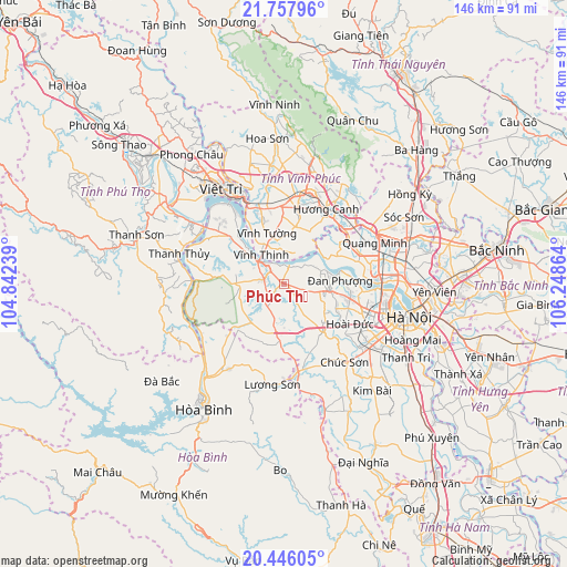
Phúc Thọ GPS coordinates[2]
21° 6' 12.42" North, 105° 32' 43.836" East
| Map corner | latitude | longitude |
|---|---|---|
| Upper-left | 21.75796°, | 104.84239° |
| Center: | 21.10345°, | 105.54551° |
| Lower-right: | 20.44605°, | 106.24864° |
| Map W x H: | 145.9×145.9 km | = 90.7×90.7mi |
| max Lat: | 23.27841° ⇑22% North |
| Phúc Thọ: | 21.10345° |
| min Lat: | ⇓78% South 8.65724° |
| min Long | Phúc Thọ | max Long |
| 102.4579° | 105.54551° | 112.72541° |
| W 25.1%⇐ | ⇒74.9% E |
Elevation
Elevation of Phúc Thọ is 17 m = 56 ft, and this is 112.5 m = 369 ft below average elevation for this country.
| Max E: |
1592 m = 5223 ft | 45.4% |
| Avg. | 129.5 m = 425 ft | |
| Phúc Thọ | 17 m = 56 ft | |
Min E: |
-1 m = -3 ft | 54.6% |
See also: Vietnam elevation on elevation.city.
Geographical zone
Phúc Thọ is located in North Torrid zone (between Equator and Tropic of Cancer). Distance of this Northern Tropic circle is 259.4 km =161.2 mi to North.| Distance of | km | miles | from Phúc Thọ |
|---|---|---|---|
| North Pole | 7660.6 | 4760.1 | to North |
| Arctic Circle | 5054.7 | 3140.8 | to North |
| Tropic Cancer | 259.4 | 161.2 | to North |
| Equator | 2346.5 | 1458 | to South |


Nearby cities:
15 places around Phúc Thọ: (largest is in red/bold)
• Chúc Sơn
25.7 km =16 mi,  140°
140°
• Cầu Diễn
24 km =14.9 mi,  107°
107°
• Hương Canh
22.2 km =13.8 mi,  28°
28°
• Liên Quan
6.2 km =3.9 mi,  145°
145°
• Lương Sơn
25.9 km =16.1 mi,  184°
184°
• Mê Linh
20.2 km =12.6 mi,  63°
63°
• Phùng
11.9 km =7.4 mi,  97°
97°
• Phúc Yên
22.2 km =13.8 mi,  48°
48°
• Quốc Oai
16 km =9.9 mi, 141°
• Sơn Tây
5.8 km =3.6 mi,  315°
315°
• Trôi
17.1 km =10.6 mi, 102°
• Tây Đằng
16.6 km =10.3 mi,  309°
309°
• Vĩnh Tường
13 km =8.1 mi,  344°
344°
• Vĩnh Yên
23.7 km =14.7 mi,  15°
15°
• Yên Lạc
15.1 km =9.4 mi,  10°
10°
Sources, notices
• [Note1] Compared only with cities in Vietnam existing in our database
• [Src1] Map data: © OpenStreetMap contributors (CC-BY-SA)
• [Src2] Other city data from geonames.org with taken over terms of usage.
• [Src3] Geographical zone / Annual Mean Temperature by Robert A. Rohde @ Wikipedia
