Lý Sơn geodata
Lý Sơn (Quảng Ngãi Province) is a seat of a second-order administrative division; located in Vietnam in Asia/Ho_Chi_Minh (GMT+7) time zone. In our database, there are 94 cities with bigger population. Compared to other cities in Vietnam, 55.3% of cities are located further ↑North; 98.2% of cities are located further ←West and 59.2% of cities have lower elevation than Lý Sơn. Note1


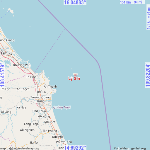
Lý Sơn GPS coordinates[2]
15° 22' 19.128" North, 109° 7' 8.076" East
| Map corner | latitude | longitude |
|---|---|---|
| Upper-left | 16.04883°, | 108.41579° |
| Center: | 15.37198°, | 109.11891° |
| Lower-right: | 14.69292°, | 109.82204° |
| Map W x H: | 150.8×150.8 km | = 93.7×93.7mi |
| max Lat: | 23.27841° ⇑55.3% North |
| Lý Sơn: | 15.37198° |
| min Lat: | ⇓44.7% South 8.65724° |
| min Long | Lý Sơn | max Long |
| 102.4579° | 109.11891° | 112.72541° |
| W 98.2%⇐ | ⇒1.8% E |
Elevation
Elevation of Lý Sơn is 22 m = 72 ft, and this is 107.5 m = 353 ft below average elevation for this country.
| Max E: |
1592 m = 5223 ft | 40.8% |
| Avg. | 129.5 m = 425 ft | |
| Lý Sơn | 22 m = 72 ft | |
Min E: |
-1 m = -3 ft | 59.2% |
See also: Vietnam elevation on elevation.city.
Geographical zone
Lý Sơn is located in North Torrid zone (between Equator and Tropic of Cancer). Distance of this Northern Tropic circle is 896.7 km =557.2 mi to North.| Distance of | km | miles | from Lý Sơn |
|---|---|---|---|
| North Pole | 8297.9 | 5156.1 | to North |
| Arctic Circle | 5692 | 3536.8 | to North |
| Tropic Cancer | 896.7 | 557.2 | to North |
| Equator | 1709.2 | 1062 | to South |


Nearby cities:
15 places around Lý Sơn: (largest is in red/bold)
• Ba Tơ
79.4 km =49.3 mi,  211°
211°
• Bình Sơn
39.2 km =24.4 mi,  257°
257°
• Minh Long
66.2 km =41.1 mi,  222°
222°
• Mộ Đức
52.7 km =32.7 mi, 208°
• Nghĩa Hành
51.6 km =32.1 mi,  225°
225°
• Núi Thành
49.7 km =30.9 mi,  277°
277°
• Pho Duc
64.4 km =40 mi,  195°
195°
• Phú Ninh
78.5 km =48.8 mi,  285°
285°
• Quảng Ngãi
44.8 km =27.8 mi, 231°
• Sơn Hà
78.7 km =48.9 mi,  242°
242°
• Sơn Tịnh
42 km =26.1 mi, 235°
• Tam Kỳ
72.7 km =45.2 mi, 287°
• Trà Bồng
65.8 km =40.9 mi, 258°
• Tây Trà
84.5 km =52.5 mi,  254°
254°
• Tư Nghĩa
44.8 km =27.8 mi, 224°
Sources, notices
• [Note1] Compared only with cities in Vietnam existing in our database
• [Src1] Map data: © OpenStreetMap contributors (CC-BY-SA)
• [Src2] Other city data from geonames.org with taken over terms of usage.
• [Src3] Geographical zone / Annual Mean Temperature by Robert A. Rohde @ Wikipedia
