Ea Kar geodata
Ea Kar (Đắk Lắk) is a seat of a second-order administrative division; located in Vietnam in Asia/Ho_Chi_Minh (GMT+7) time zone. In our database, there are 94 cities with bigger population. Compared to other cities in Vietnam, 64.4% of cities are located further ↑North; 91.2% of cities are located further ←West and 89.9% of cities have lower elevation than Ea Kar. Note1


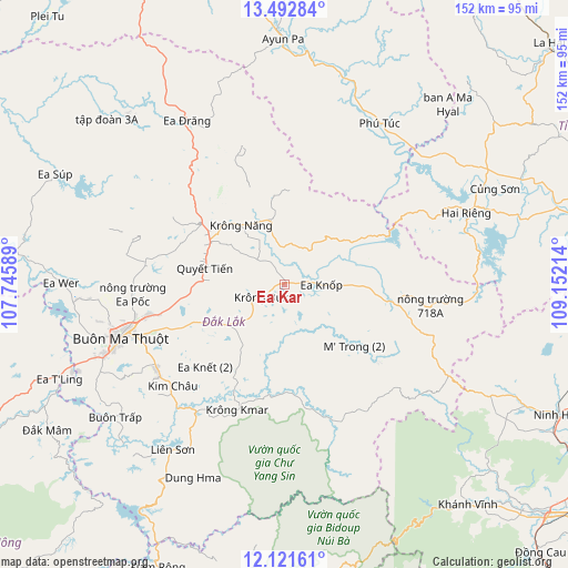
Ea Kar GPS coordinates[2]
12° 48' 29.376" North, 108° 26' 56.436" East
| Map corner | latitude | longitude |
|---|---|---|
| Upper-left | 13.49284°, | 107.74589° |
| Center: | 12.80816°, | 108.44901° |
| Lower-right: | 12.12161°, | 109.15214° |
| Map W x H: | 152.5×152.5 km | = 94.8×94.8mi |
| max Lat: | 23.27841° ⇑64.4% North |
| Ea Kar: | 12.80816° |
| min Lat: | ⇓35.6% South 8.65724° |
| min Long | Ea Kar | max Long |
| 102.4579° | 108.44901° | 112.72541° |
| W 91.2%⇐ | ⇒8.8% E |
Elevation
Elevation of Ea Kar is 490 m = 1608 ft, and this is 360.5 m = 1183 ft above average elevation for this country.
| Max E: |
1592 m = 5223 ft | 10.1% |
| Ea Kar | 490 m 1608 ft | |
| Avg. | 129.5 m = 425 ft | |
Min E: |
-1 m = -3 ft | 89.9% |
See also: Vietnam elevation on elevation.city.
Geographical zone
Ea Kar is located in North Torrid zone (between Equator and Tropic of Cancer). Distance of this Northern Tropic circle is 1181.8 km =734.3 mi to North.| Distance of | km | miles | from Ea Kar |
|---|---|---|---|
| North Pole | 8582.9 | 5333.2 | to North |
| Arctic Circle | 5977 | 3713.9 | to North |
| Tropic Cancer | 1181.8 | 734.3 | to North |
| Equator | 1424.1 | 884.9 | to South |


Nearby cities:
15 places around Ea Kar: (largest is in red/bold)
• A Yun Pa
65.9 km =40.9 mi,  358°
358°
• Buôn Ma Thuột
47.3 km =29.4 mi,  250°
250°
• Buôn Trấp
58 km =36 mi,  231°
231°
• Củng Sơn
63.4 km =39.4 mi,  64°
64°
• Ea Drăng
51.1 km =31.8 mi,  329°
329°
• Ea Súp
67.5 km =41.9 mi,  295°
295°
• Ea T’ling
64.8 km =40.3 mi, 247°
• Hai Riêng
52.2 km =32.4 mi,  68°
68°
• Krông Kmar
36 km =22.4 mi,  200°
200°
• Krông Năng
19.6 km =12.2 mi,  324°
324°
• Lắk
53.1 km =33 mi,  213°
213°
• M’Đrăk
32.6 km =20.3 mi,  102°
102°
• Phú Túc
50.5 km =31.4 mi,  31°
31°
• Phước An
19.2 km =11.9 mi,  236°
236°
• Quảng Phú
40.3 km =25 mi,  271°
271°
Sources, notices
• [Note1] Compared only with cities in Vietnam existing in our database
• [Src1] Map data: © OpenStreetMap contributors (CC-BY-SA)
• [Src2] Other city data from geonames.org with taken over terms of usage.
• [Src3] Geographical zone / Annual Mean Temperature by Robert A. Rohde @ Wikipedia
