Củng Sơn geodata
Củng Sơn (Phú Yên) is a seat of a second-order administrative division; located in Vietnam in Asia/Ho_Chi_Minh (GMT+7) time zone. In our database, there are 94 cities with bigger population. Compared to other cities in Vietnam, 63.8% of cities are located further ↑North; 96.6% of cities are located further ←West and 69.7% of cities have lower elevation than Củng Sơn. Note1


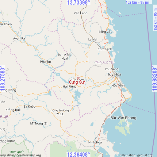
Củng Sơn GPS coordinates[2]
13° 2' 59.928" North, 108° 58' 44.22" East
| Map corner | latitude | longitude |
|---|---|---|
| Upper-left | 13.73398°, | 108.27583° |
| Center: | 13.04998°, | 108.97895° |
| Lower-right: | 12.36408°, | 109.68208° |
| Map W x H: | 152.3×152.3 km | = 94.6×94.6mi |
| max Lat: | 23.27841° ⇑63.8% North |
| Củng Sơn: | 13.04998° |
| min Lat: | ⇓36.2% South 8.65724° |
| min Long | Củng Sơn | max Long |
| 102.4579° | 108.97895° | 112.72541° |
| W 96.6%⇐ | ⇒3.4% E |
Elevation
Elevation of Củng Sơn is 55 m = 180 ft, and this is 74.5 m = 244 ft below average elevation for this country.
| Max E: |
1592 m = 5223 ft | 30.3% |
| Avg. | 129.5 m = 425 ft | |
| Củng Sơn | 55 m = 180 ft | |
Min E: |
-1 m = -3 ft | 69.7% |
See also: Vietnam elevation on elevation.city.
Geographical zone
Củng Sơn is located in North Torrid zone (between Equator and Tropic of Cancer). Distance of this Northern Tropic circle is 1154.9 km =717.6 mi to North.| Distance of | km | miles | from Củng Sơn |
|---|---|---|---|
| North Pole | 8556 | 5316.5 | to North |
| Arctic Circle | 5950.2 | 3697.3 | to North |
| Tropic Cancer | 1154.9 | 717.6 | to North |
| Equator | 1451 | 901.6 | to South |


Nearby cities:
15 places around Củng Sơn: (largest is in red/bold)
• A Yun Pa
70.6 km =43.9 mi,  303°
303°
• Chí Thạnh
38.5 km =23.9 mi,  41°
41°
• Ea Kar
63.4 km =39.4 mi,  244°
244°
• Hai Riêng
11.8 km =7.3 mi,  228°
228°
• Ia Pa
78.1 km =48.5 mi,  313°
313°
• Krông Năng
69.6 km =43.2 mi,  260°
260°
• La Hai
39 km =24.2 mi,  21°
21°
• M’Đrăk
42.4 km =26.3 mi,  217°
217°
• Ninh Hòa
64 km =39.8 mi,  165°
165°
• Phú Túc
35.3 km =21.9 mi, 297°
• Phước An
82.4 km =51.2 mi, 242°
• Sông Cầu
52.3 km =32.5 mi,  30°
30°
• Tuy Hòa
37.4 km =23.2 mi,  82°
82°
• Vân Canh
63.4 km =39.4 mi,  1°
1°
• Vạn Giã
47.7 km =29.6 mi,  146°
146°
Sources, notices
• [Note1] Compared only with cities in Vietnam existing in our database
• [Src1] Map data: © OpenStreetMap contributors (CC-BY-SA)
• [Src2] Other city data from geonames.org with taken over terms of usage.
• [Src3] Geographical zone / Annual Mean Temperature by Robert A. Rohde @ Wikipedia
