Ea T’ling geodata
Ea T’ling (Ðắk Nông) is a seat of a second-order administrative division; located in Vietnam in Asia/Ho_Chi_Minh (GMT+7) time zone. In our database, there are 94 cities with bigger population. Compared to other cities in Vietnam, 65.3% of cities are located further ↑North; 83.8% of cities are located further ←West and 86.1% of cities have lower elevation than Ea T’ling. Note1


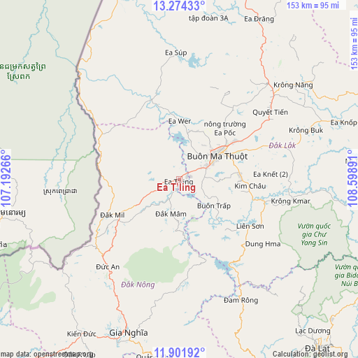
Ea T’ling GPS coordinates[2]
12° 35' 20.544" North, 107° 53' 44.808" East
| Map corner | latitude | longitude |
|---|---|---|
| Upper-left | 13.27433°, | 107.19266° |
| Center: | 12.58904°, | 107.89578° |
| Lower-right: | 11.90192°, | 108.59891° |
| Map W x H: | 152.6×152.6 km | = 94.8×94.8mi |
| max Lat: | 23.27841° ⇑65.3% North |
| Ea T’ling: | 12.58904° |
| min Lat: | ⇓34.7% South 8.65724° |
| min Long | Ea T’ling | max Long |
| 102.4579° | 107.89578° | 112.72541° |
| W 83.8%⇐ | ⇒16.2% E |
Elevation
Elevation of Ea T’ling is 349 m = 1145 ft, and this is 219.5 m = 720 ft above average elevation for this country.
| Max E: |
1592 m = 5223 ft | 13.9% |
| Ea T’ling | 349 m 1145 ft | |
| Avg. | 129.5 m = 425 ft | |
Min E: |
-1 m = -3 ft | 86.1% |
See also: Vietnam elevation on elevation.city.
Geographical zone
Ea T’ling is located in North Torrid zone (between Equator and Tropic of Cancer). Distance of this Northern Tropic circle is 1206.1 km =749.4 mi to North.| Distance of | km | miles | from Ea T’ling |
|---|---|---|---|
| North Pole | 8607.3 | 5348.3 | to North |
| Arctic Circle | 6001.4 | 3729.1 | to North |
| Tropic Cancer | 1206.1 | 749.4 | to North |
| Equator | 1399.8 | 869.8 | to South |


Nearby cities:
15 places around Ea T’ling: (largest is in red/bold)
• Buôn Ma Thuột
17.7 km =11 mi,  60°
60°
• Buôn Trấp
18.6 km =11.6 mi,  128°
128°
• Ea Drăng
76.5 km =47.5 mi,  26°
26°
• Ea Kar
64.8 km =40.3 mi,  67°
67°
• Ea Súp
53.1 km =33 mi,  358°
358°
• Gia Nghĩa
68.7 km =42.7 mi,  198°
198°
• Krông Kmar
48.4 km =30.1 mi,  101°
101°
• Krông Năng
63.2 km =39.3 mi,  50°
50°
• Lạc Dương
86.4 km =53.7 mi,  138°
138°
• Lắk
36.4 km =22.6 mi,  122°
122°
• Phước An
46.1 km =28.6 mi, 72°
• Quảng Phú
32.3 km =20.1 mi,  37°
37°
• Tram de Dak Mil
33.5 km =20.8 mi,  242°
242°
• Đắk Mâm
15 km =9.3 mi,  193°
193°
• Đắk Song
48.4 km =30.1 mi,  219°
219°
Sources, notices
• [Note1] Compared only with cities in Vietnam existing in our database
• [Src1] Map data: © OpenStreetMap contributors (CC-BY-SA)
• [Src2] Other city data from geonames.org with taken over terms of usage.
• [Src3] Geographical zone / Annual Mean Temperature by Robert A. Rohde @ Wikipedia
