Phú Túc geodata
Phú Túc (Gia Lai) is a seat of a second-order administrative division; located in Vietnam in Asia/Ho_Chi_Minh (GMT+7) time zone. In our database, there are 94 cities with bigger population. Compared to other cities in Vietnam, 63.3% of cities are located further ↑North; 92.8% of cities are located further ←West and 77.7% of cities have lower elevation than Phú Túc. Note1


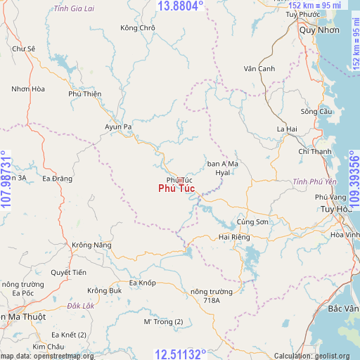
Phú Túc GPS coordinates[2]
13° 11' 48.552" North, 108° 41' 25.548" East
| Map corner | latitude | longitude |
|---|---|---|
| Upper-left | 13.8804°, | 107.98731° |
| Center: | 13.19682°, | 108.69043° |
| Lower-right: | 12.51132°, | 109.39356° |
| Map W x H: | 152.2×152.2 km | = 94.6×94.6mi |
| max Lat: | 23.27841° ⇑63.3% North |
| Phú Túc: | 13.19682° |
| min Lat: | ⇓36.7% South 8.65724° |
| min Long | Phú Túc | max Long |
| 102.4579° | 108.69043° | 112.72541° |
| W 92.8%⇐ | ⇒7.2% E |
Elevation
Elevation of Phú Túc is 135 m = 443 ft, and this is 5.5 m = 18 ft above average elevation for this country.
| Max E: |
1592 m = 5223 ft | 22.3% |
| Phú Túc | 135 m 443 ft | |
| Avg. | 129.5 m = 425 ft | |
Min E: |
-1 m = -3 ft | 77.7% |
See also: Vietnam elevation on elevation.city.
Geographical zone
Phú Túc is located in North Torrid zone (between Equator and Tropic of Cancer). Distance of this Northern Tropic circle is 1138.6 km =707.5 mi to North.| Distance of | km | miles | from Phú Túc |
|---|---|---|---|
| North Pole | 8539.7 | 5306.3 | to North |
| Arctic Circle | 5933.8 | 3687.1 | to North |
| Tropic Cancer | 1138.6 | 707.5 | to North |
| Equator | 1467.3 | 911.7 | to South |


Nearby cities:
15 places around Phú Túc: (largest is in red/bold)
• A Yun Pa
35.7 km =22.2 mi,  309°
309°
• Chí Thạnh
58.1 km =36.1 mi,  77°
77°
• Củng Sơn
35.3 km =21.9 mi,  117°
117°
• Ea Drăng
52 km =32.3 mi,  270°
270°
• Ea Kar
50.5 km =31.4 mi,  211°
211°
• Hai Riêng
33 km =20.5 mi,  137°
137°
• Ia Pa
45.3 km =28.1 mi,  325°
325°
• Krông Năng
46.4 km =28.8 mi,  233°
233°
• Kông Chro
66.7 km =41.4 mi,  344°
344°
• La Hai
49.4 km =30.7 mi,  66°
66°
• M’Đrăk
50.4 km =31.3 mi,  173°
173°
• Phước An
68.3 km =42.4 mi,  218°
218°
• Sông Cầu
64.5 km =40.1 mi,  63°
63°
• Tuy Hòa
69.2 km =43 mi,  99°
99°
• Vân Canh
57.6 km =35.8 mi,  35°
35°
Sources, notices
• [Note1] Compared only with cities in Vietnam existing in our database
• [Src1] Map data: © OpenStreetMap contributors (CC-BY-SA)
• [Src2] Other city data from geonames.org with taken over terms of usage.
• [Src3] Geographical zone / Annual Mean Temperature by Robert A. Rohde @ Wikipedia
