Long Khánh geodata
Long Khánh (Đồng Nai) is a seat of a second-order administrative division; located in Vietnam in Asia/Ho_Chi_Minh (GMT+7) time zone. In our database, there are 94 cities with bigger population. Compared to other cities in Vietnam, 75.5% of cities are located further ↑North; 77.2% of cities are located further ←West and 80.1% of cities have lower elevation than Long Khánh. Note1


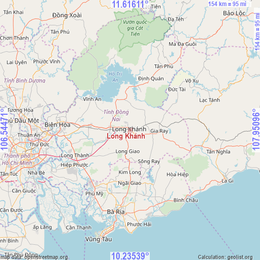
Long Khánh GPS coordinates[2]
10° 55' 35.58" North, 107° 14' 52.188" East
| Map corner | latitude | longitude |
|---|---|---|
| Upper-left | 11.61611°, | 106.54471° |
| Center: | 10.92655°, | 107.24783° |
| Lower-right: | 10.23539°, | 107.95096° |
| Map W x H: | 153.5×153.5 km | = 95.4×95.4mi |
| max Lat: | 23.27841° ⇑75.5% North |
| Long Khánh: | 10.92655° |
| min Lat: | ⇓24.5% South 8.65724° |
| min Long | Long Khánh | max Long |
| 102.4579° | 107.24783° | 112.72541° |
| W 77.2%⇐ | ⇒22.8% E |
Elevation
Elevation of Long Khánh is 175 m = 574 ft, and this is 45.5 m = 149 ft above average elevation for this country.
| Max E: |
1592 m = 5223 ft | 19.9% |
| Long Khánh | 175 m 574 ft | |
| Avg. | 129.5 m = 425 ft | |
Min E: |
-1 m = -3 ft | 80.1% |
See also: Vietnam elevation on elevation.city.
Geographical zone
Long Khánh is located in North Torrid zone (between Equator and Tropic of Cancer). Distance of Equator is 1214.9 km =754.9 mi to South.| Distance of | km | miles | from Long Khánh |
|---|---|---|---|
| North Pole | 8792.1 | 5463.2 | to North |
| Arctic Circle | 6186.3 | 3844 | to North |
| Tropic Cancer | 1391 | 864.3 | to North |
| Equator | 1214.9 | 754.9 | to South |


Nearby cities:
15 places around Long Khánh: (largest is in red/bold)
• Biên Hòa
46.3 km =28.8 mi,  272°
272°
• Gia Ray
16.8 km =10.4 mi,  90°
90°
• Long Thành
35.9 km =22.3 mi,  244°
244°
• Nhơn Trạch
45.8 km =28.5 mi, 240°
• Phuoc Tho
48.5 km =30.1 mi,  177°
177°
• Thành Phố Bà Rịa
48.6 km =30.2 mi,  190°
190°
• Thị Trấn Ngải Giao
31.1 km =19.3 mi, 180°
• Thị Trấn Phú Mỹ
41.7 km =25.9 mi,  210°
210°
• Thị Trấn Phước Bửu
46.7 km =29 mi,  158°
158°
• Thị Xã Phú Mỹ
41.9 km =26 mi,  197°
197°
• Thống Nhất
11.5 km =7.1 mi,  283°
283°
• Trảng Bom
26.6 km =16.5 mi, 276°
• Tân Phú
43.6 km =27.1 mi,  28°
28°
• Võ Xu
44.7 km =27.8 mi,  49°
49°
• Vĩnh An
29.4 km =18.3 mi,  307°
307°
Sources, notices
• [Note1] Compared only with cities in Vietnam existing in our database
• [Src1] Map data: © OpenStreetMap contributors (CC-BY-SA)
• [Src2] Other city data from geonames.org with taken over terms of usage.
• [Src3] Geographical zone / Annual Mean Temperature by Robert A. Rohde @ Wikipedia
