Trảng Bom geodata
Trảng Bom (Đồng Nai) is a seat of a second-order administrative division; located in Vietnam in Asia/Ho_Chi_Minh (GMT+7) time zone. In our database, there are 94 cities with bigger population. Compared to other cities in Vietnam, 74.9% of cities are located further ↑North; 74.4% of cities are located further ←West and 71% of cities have lower elevation than Trảng Bom. Note1


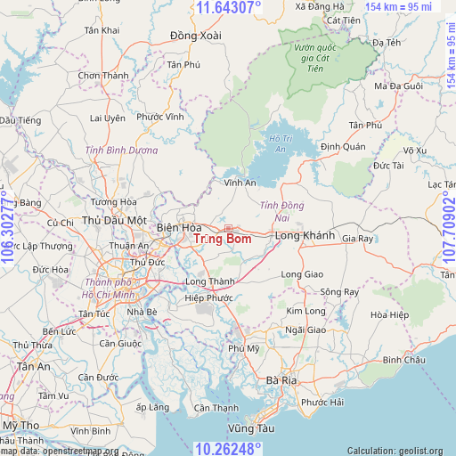
Trảng Bom GPS coordinates[2]
10° 57' 12.888" North, 107° 0' 21.204" East
| Map corner | latitude | longitude |
|---|---|---|
| Upper-left | 11.64307°, | 106.30277° |
| Center: | 10.95358°, | 107.00589° |
| Lower-right: | 10.26248°, | 107.70902° |
| Map W x H: | 153.5×153.5 km | = 95.4×95.4mi |
| max Lat: | 23.27841° ⇑74.9% North |
| Trảng Bom: | 10.95358° |
| min Lat: | ⇓25.1% South 8.65724° |
| min Long | Trảng Bom | max Long |
| 102.4579° | 107.00589° | 112.72541° |
| W 74.4%⇐ | ⇒25.6% E |
Elevation
Elevation of Trảng Bom is 61 m = 200 ft, and this is 68.5 m = 225 ft below average elevation for this country.
| Max E: |
1592 m = 5223 ft | 29% |
| Avg. | 129.5 m = 425 ft | |
| Trảng Bom | 61 m = 200 ft | |
Min E: |
-1 m = -3 ft | 71% |
See also: Vietnam elevation on elevation.city.
Geographical zone
Trảng Bom is located in North Torrid zone (between Equator and Tropic of Cancer). Distance of Equator is 1217.9 km =756.8 mi to South.| Distance of | km | miles | from Trảng Bom |
|---|---|---|---|
| North Pole | 8789.1 | 5461.3 | to North |
| Arctic Circle | 6183.3 | 3842.1 | to North |
| Tropic Cancer | 1388 | 862.5 | to North |
| Equator | 1217.9 | 756.8 | to South |


Nearby cities:
15 places around Trảng Bom: (largest is in red/bold)
• Biên Hòa
19.8 km =12.3 mi,  267°
267°
• Dĩ An
26.3 km =16.3 mi,  258°
258°
• Long Khánh
26.6 km =16.5 mi,  96°
96°
• Long Thành
19.3 km =12 mi,  198°
198°
• Lái Thiêu
33.9 km =21.1 mi, 260°
• Nhơn Trạch
28.9 km =18 mi,  207°
207°
• Quận Bình Thạnh
37.7 km =23.4 mi,  243°
243°
• Quận Bốn
38.8 km =24.1 mi, 237°
• Quận Chín
28.6 km =17.8 mi, 243°
• Quận Hai
33.3 km =20.7 mi, 237°
• Quận Một
38.6 km =24 mi, 240°
• Thống Nhất
15.3 km =9.5 mi,  91°
91°
• Thủ Đức
28.1 km =17.5 mi,  245°
245°
• Uyen Hung
27.8 km =17.3 mi,  301°
301°
• Vĩnh An
15.4 km =9.6 mi,  11°
11°
Sources, notices
• [Note1] Compared only with cities in Vietnam existing in our database
• [Src1] Map data: © OpenStreetMap contributors (CC-BY-SA)
• [Src2] Other city data from geonames.org with taken over terms of usage.
• [Src3] Geographical zone / Annual Mean Temperature by Robert A. Rohde @ Wikipedia
