Võ Xu geodata
Võ Xu (Bình Thuận) is a seat of a second-order administrative division; located in Vietnam in Asia/Ho_Chi_Minh (GMT+7) time zone. In our database, there are 94 cities with bigger population. Compared to other cities in Vietnam, 73.2% of cities are located further ↑North; 79.4% of cities are located further ←West and 76.8% of cities have lower elevation than Võ Xu. Note1


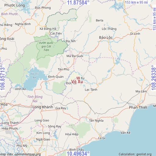
Võ Xu GPS coordinates[2]
11° 11' 12.876" North, 107° 33' 36.9" East
| Map corner | latitude | longitude |
|---|---|---|
| Upper-left | 11.87584°, | 106.85713° |
| Center: | 11.18691°, | 107.56025° |
| Lower-right: | 10.49634°, | 108.26338° |
| Map W x H: | 153.4×153.4 km | = 95.3×95.3mi |
| max Lat: | 23.27841° ⇑73.2% North |
| Võ Xu: | 11.18691° |
| min Lat: | ⇓26.8% South 8.65724° |
| min Long | Võ Xu | max Long |
| 102.4579° | 107.56025° | 112.72541° |
| W 79.4%⇐ | ⇒20.6% E |
Elevation
Elevation of Võ Xu is 123 m = 404 ft, and this is 6.5 m = 21 ft below average elevation for this country.
| Max E: |
1592 m = 5223 ft | 23.2% |
| Avg. | 129.5 m = 425 ft | |
| Võ Xu | 123 m = 404 ft | |
Min E: |
-1 m = -3 ft | 76.8% |
See also: Vietnam elevation on elevation.city.
Geographical zone
Võ Xu is located in North Torrid zone (between Equator and Tropic of Cancer). Distance of Equator is 1243.9 km =772.9 mi to South.| Distance of | km | miles | from Võ Xu |
|---|---|---|---|
| North Pole | 8763.2 | 5445.2 | to North |
| Arctic Circle | 6157.3 | 3826 | to North |
| Tropic Cancer | 1362.1 | 846.4 | to North |
| Equator | 1243.9 | 772.9 | to South |


Nearby cities:
15 places around Võ Xu: (largest is in red/bold)
• Bảo Lộc
48.4 km =30.1 mi,  33°
33°
• Gia Ray
33.8 km =21 mi,  210°
210°
• La Gi
63 km =39.1 mi,  158°
158°
• Long Khánh
44.7 km =27.8 mi,  229°
229°
• Lộc Thắng
57.5 km =35.7 mi, 31°
• Ma Lâm
63.4 km =39.4 mi,  101°
101°
• Ma Đa Gui
22.4 km =13.9 mi,  352°
352°
• Phan Thiết
65.7 km =40.8 mi,  115°
115°
• Thuận Nam
51.1 km =31.8 mi,  137°
137°
• Thống Nhất
52.3 km =32.5 mi,  239°
239°
• Tánh Linh
17.4 km =10.8 mi,  130°
130°
• Tân Phú
16.5 km =10.3 mi,  305°
305°
• Vĩnh An
58.3 km =36.2 mi,  259°
259°
• Đạ Tẻh
36.9 km =22.9 mi, 348°
• Đồng Nai
48.6 km =30.2 mi,  334°
334°
Sources, notices
• [Note1] Compared only with cities in Vietnam existing in our database
• [Src1] Map data: © OpenStreetMap contributors (CC-BY-SA)
• [Src2] Other city data from geonames.org with taken over terms of usage.
• [Src3] Geographical zone / Annual Mean Temperature by Robert A. Rohde @ Wikipedia
