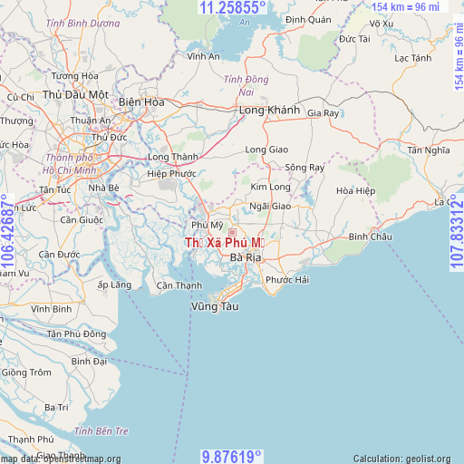
Thị Xã Phú Mỹ geodata
Thị Xã Phú Mỹ (Bà Rịa-Vũng Tàu) is a section of populated place; located in Vietnam in Asia/Ho_Chi_Minh (GMT+7) time zone. With population of 221,030 people, there are 9 cities with bigger population in this country. Compared to other cities in Vietnam, 82.7% of cities are located further ↑North; 75.9% of cities are located further ←West and 69% of cities have lower elevation than Thị Xã Phú Mỹ. Note1
Thị Xã Phú Mỹ GPS coordinates[2]
10° 34' 5.34" North, 107° 7' 47.964" East
| Map corner | latitude | longitude |
|---|---|---|
| Upper-left | 11.25855°, | 106.42687° |
| Center: | 10.56815°, | 107.12999° |
| Lower-right: | 9.87619°, | 107.83312° |
| Map W x H: | 153.7×153.7 km | = 95.5×95.5mi |
| max Lat: | 23.27841° ⇑82.7% North |
| Thị Xã Phú Mỹ: | 10.56815° |
| min Lat: | ⇓17.3% South 8.65724° |
| min Long | Thị Xã Phú | max Long |
| 102.4579° | 107.12999° | 112.72541° |
| W 75.9%⇐ | ⇒24.1% E |
Elevation
Elevation of Thị Xã Phú Mỹ is 53 m = 174 ft, and this is 76.5 m = 251 ft below average elevation for this country.
| Max E: |
1592 m = 5223 ft | 31% |
| Avg. | 129.5 m = 425 ft | |
| Thị Xã Phú Mỹ | 53 m = 174 ft | |
Min E: |
-1 m = -3 ft | 69% |
See also: Thị Xã Phú Mỹ elevation on elevation.city.
Geographical zone
Thị Xã Phú Mỹ is located in North Torrid zone (between Equator and Tropic of Cancer). Distance of Equator is 1175.1 km =730.2 mi to South.| Distance of | km | miles | from Thị Xã Phú Mỹ |
|---|---|---|---|
| North Pole | 8832 | 5487.9 | to North |
| Arctic Circle | 6226.1 | 3868.7 | to North |
| Tropic Cancer | 1430.9 | 889.1 | to North |
| Equator | 1175.1 | 730.2 | to South |


Nearby cities:
15 places around Thị Xã Phú Mỹ: (largest is in red/bold)
• Cần Giờ
25.9 km =16.1 mi,  227°
227°
• Long Khánh
41.9 km =26 mi,  17°
17°
• Long Thành
31.4 km =19.5 mi,  321°
321°
• Nhà Bè
44.9 km =27.9 mi,  288°
288°
• Nhơn Trạch
32 km =19.9 mi,  302°
302°
• Phuoc Tho
17.6 km =10.9 mi,  119°
119°
• Quận Bảy
45.9 km =28.5 mi,  290°
290°
• Thành Phố Bà Rịa
9 km =5.6 mi,  152°
152°
• Thị Trấn Long Điền
12.9 km =8 mi,  135°
135°
• Thị Trấn Ngải Giao
15.4 km =9.6 mi,  55°
55°
• Thị Trấn Phú Mỹ
9.2 km =5.7 mi,  295°
295°
• Thị Trấn Phước Bửu
30 km =18.6 mi,  97°
97°
• Thống Nhất
42.6 km =26.5 mi,  2°
2°
• Trảng Bom
44.9 km =27.9 mi,  342°
342°
• Vũng Tàu
25.2 km =15.7 mi,  191°
191°
Sources, notices
• [Note1] Compared only with cities in Vietnam existing in our database
• [Src1] Map data: © OpenStreetMap contributors (CC-BY-SA)
• [Src2] Other city data from geonames.org with taken over terms of usage.
• [Src3] Geographical zone / Annual Mean Temperature by Robert A. Rohde @ Wikipedia


