Long Thành geodata
Long Thành (Đồng Nai) is a seat of a second-order administrative division; located in Vietnam in Asia/Ho_Chi_Minh (GMT+7) time zone. In our database, there are 94 cities with bigger population. Compared to other cities in Vietnam, 78.6% of cities are located further ↑North; 73.6% of cities are located further ←West and 57.1% of cities have lower elevation than Long Thành. Note1


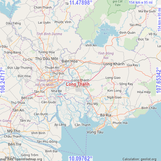
Long Thành GPS coordinates[2]
10° 47' 20.724" North, 106° 57' 1.044" East
| Map corner | latitude | longitude |
|---|---|---|
| Upper-left | 11.47898°, | 106.24717° |
| Center: | 10.78909°, | 106.95029° |
| Lower-right: | 10.09762°, | 107.65342° |
| Map W x H: | 153.6×153.6 km | = 95.4×95.4mi |
| max Lat: | 23.27841° ⇑78.6% North |
| Long Thành: | 10.78909° |
| min Lat: | ⇓21.4% South 8.65724° |
| min Long | Long Thành | max Long |
| 102.4579° | 106.95029° | 112.72541° |
| W 73.6%⇐ | ⇒26.4% E |
Elevation
Elevation of Long Thành is 19 m = 62 ft, and this is 110.5 m = 363 ft below average elevation for this country.
| Max E: |
1592 m = 5223 ft | 42.9% |
| Avg. | 129.5 m = 425 ft | |
| Long Thành | 19 m = 62 ft | |
Min E: |
-1 m = -3 ft | 57.1% |
See also: Vietnam elevation on elevation.city.
Geographical zone
Long Thành is located in North Torrid zone (between Equator and Tropic of Cancer). Distance of Equator is 1199.6 km =745.4 mi to South.| Distance of | km | miles | from Long Thành |
|---|---|---|---|
| North Pole | 8807.4 | 5472.7 | to North |
| Arctic Circle | 6201.5 | 3853.4 | to North |
| Tropic Cancer | 1406.3 | 873.8 | to North |
| Equator | 1199.6 | 745.4 | to South |


Nearby cities:
15 places around Long Thành: (largest is in red/bold)
• Biên Hòa
22.1 km =13.7 mi,  321°
321°
• Dĩ An
23.7 km =14.7 mi,  303°
303°
• Nhà Bè
25.1 km =15.6 mi,  245°
245°
• Nhơn Trạch
10.4 km =6.5 mi,  224°
224°
• Quận Ba
28.9 km =18 mi,  266°
266°
• Quận Bình Thạnh
27.7 km =17.2 mi, 273°
• Quận Bảy
24.9 km =15.5 mi, 249°
• Quận Bốn
26.8 km =16.7 mi,  264°
264°
• Quận Chín
20.4 km =12.7 mi,  286°
286°
• Quận Hai
21.9 km =13.6 mi, 270°
• Quận Một
27.4 km =17 mi, 268°
• Thị Trấn Phú Mỹ
23.5 km =14.6 mi,  151°
151°
• Thống Nhất
27.9 km =17.3 mi,  49°
49°
• Thủ Đức
20.6 km =12.8 mi, 288°
• Trảng Bom
19.3 km =12 mi,  18°
18°
Sources, notices
• [Note1] Compared only with cities in Vietnam existing in our database
• [Src1] Map data: © OpenStreetMap contributors (CC-BY-SA)
• [Src2] Other city data from geonames.org with taken over terms of usage.
• [Src3] Geographical zone / Annual Mean Temperature by Robert A. Rohde @ Wikipedia
