Sa Dec geodata
Sa Dec (Đồng Tháp) is a seat of a second-order administrative division; located in Vietnam in Asia/Ho_Chi_Minh (GMT+7) time zone. With population of 203,588 people, there are 12 cities with bigger population in this country. Compared to other cities in Vietnam, 87.4% of cities are located further ↑North; 65.9% of cities are located further →East and 99.2% of cities have higher elevation than Sa Dec. Note1


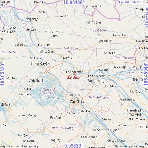
Sa Dec GPS coordinates[2]
10° 17' 27.06" North, 105° 45' 22.86" East
| Map corner | latitude | longitude |
|---|---|---|
| Upper-left | 10.98189°, | 105.05323° |
| Center: | 10.29085°, | 105.75635° |
| Lower-right: | 9.59829°, | 106.45948° |
| Map W x H: | 153.8×153.8 km | = 95.6×95.6mi |
| max Lat: | 23.27841° ⇑87.4% North |
| Sa Dec: | 10.29085° |
| min Lat: | ⇓12.6% South 8.65724° |
| min Long | Sa Dec | max Long |
| 102.4579° | 105.75635° | 112.72541° |
| W 34.1%⇐ | ⇒65.9% E |
Elevation
Elevation of Sa Dec is 1 m = 3 ft, and this is 128.5 m = 422 ft below average elevation for this country.
| Max E: |
1592 m = 5223 ft | 99.2% |
| Avg. | 129.5 m = 425 ft | |
| Sa Dec | 1 m = 3 ft | |
Min E: |
-1 m = -3 ft | 0.8% |
See also: Sa Dec elevation on elevation.city.
Geographical zone
Sa Dec is located in North Torrid zone (between Equator and Tropic of Cancer). Distance of Equator is 1144.2 km =711 mi to South.| Distance of | km | miles | from Sa Dec |
|---|---|---|---|
| North Pole | 8862.8 | 5507.1 | to North |
| Arctic Circle | 6256.9 | 3887.9 | to North |
| Tropic Cancer | 1461.7 | 908.3 | to North |
| Equator | 1144.2 | 711 | to South |


Nearby cities:
15 places around Sa Dec: (largest is in red/bold)
• An Hòa
1.5 km =0.9 mi,  297°
297°
• Bình Minh
25.8 km =16 mi,  163°
163°
• Bình Thủy
24.1 km =15 mi,  184°
184°
• Cao Lãnh
23.2 km =14.4 mi,  324°
324°
• Cái Răng
32.2 km =20 mi, 181°
• Cái Tàu Hạ
13 km =8.1 mi,  105°
105°
• Cần Thơ
28.4 km =17.6 mi,  172°
172°
• Lai Vung
10.4 km =6.5 mi,  267°
267°
• Long Hồ
30.1 km =18.7 mi, 111°
• Lấp Vò
27.1 km =16.8 mi,  286°
286°
• Mỹ Thọ
18.2 km =11.3 mi,  338°
338°
• Thị Trấn Tân Thành
18.3 km =11.4 mi,  257°
257°
• Thốt Nốt
24.4 km =15.2 mi, 265°
• Vĩnh Long
24 km =14.9 mi,  99°
99°
• Ô Môn
24.9 km =15.5 mi,  215°
215°
Sources, notices
• [Note1] Compared only with cities in Vietnam existing in our database
• [Src1] Map data: © OpenStreetMap contributors (CC-BY-SA)
• [Src2] Other city data from geonames.org with taken over terms of usage.
• [Src3] Geographical zone / Annual Mean Temperature by Robert A. Rohde @ Wikipedia
