Yên Châu geodata
Yên Châu (Sơn La) is a seat of a second-order administrative division; located in Vietnam in Asia/Ho_Chi_Minh (GMT+7) time zone. In our database, there are 94 cities with bigger population. Compared to other cities in Vietnam, 76.5% of cities are located further ↓South; 94.6% of cities are located further →East and 85% of cities have lower elevation than Yên Châu. Note1


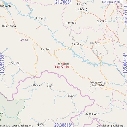
Yên Châu GPS coordinates[2]
21° 2' 45.024" North, 104° 18' 3.636" East
| Map corner | latitude | longitude |
|---|---|---|
| Upper-left | 21.7006°, | 103.59789° |
| Center: | 21.04584°, | 104.30101° |
| Lower-right: | 20.38818°, | 105.00414° |
| Map W x H: | 145.9×145.9 km | = 90.7×90.7mi |
| max Lat: | 23.27841° ⇑23.5% North |
| Yên Châu: | 21.04584° |
| min Lat: | ⇓76.5% South 8.65724° |
| min Long | Yên Châu | max Long |
| 102.4579° | 104.30101° | 112.72541° |
| W 5.4%⇐ | ⇒94.6% E |
Elevation
Elevation of Yên Châu is 294 m = 965 ft, and this is 164.5 m = 540 ft above average elevation for this country.
| Max E: |
1592 m = 5223 ft | 15% |
| Yên Châu | 294 m 965 ft | |
| Avg. | 129.5 m = 425 ft | |
Min E: |
-1 m = -3 ft | 85% |
See also: Vietnam elevation on elevation.city.
Geographical zone
Yên Châu is located in North Torrid zone (between Equator and Tropic of Cancer). Distance of this Northern Tropic circle is 265.8 km =165.2 mi to North.| Distance of | km | miles | from Yên Châu |
|---|---|---|---|
| North Pole | 7667 | 4764.1 | to North |
| Arctic Circle | 5061.1 | 3144.8 | to North |
| Tropic Cancer | 265.8 | 165.2 | to North |
| Equator | 2340.1 | 1454.1 | to South |


Nearby cities:
15 places around Yên Châu: (largest is in red/bold)
• Bắc Yên
26.1 km =16.2 mi,  31°
31°
• Hát Lót
26.3 km =16.3 mi,  309°
309°
• Hạ Hòa
92.9 km =57.7 mi,  51°
51°
• Mù Cang Chải
92.2 km =57.3 mi,  346°
346°
• Mường Lát
65.4 km =40.6 mi,  151°
151°
• Mộc Châu
39.7 km =24.7 mi,  122°
122°
• Phù Yên
43 km =26.7 mi,  55°
55°
• Sông Mã
57.2 km =35.5 mi,  270°
270°
• Sơn La
50.4 km =31.3 mi, 308°
• Sơn Thịnh
65 km =40.4 mi, 27°
• Thanh Sơn
92.6 km =57.5 mi,  79°
79°
• Thị Trấn Thuận Châu
76.9 km =47.8 mi,  304°
304°
• Thị Trấn Trạm Tấu
47.5 km =29.5 mi,  9°
9°
• Yên Lập
85.3 km =53 mi,  66°
66°
• Ít Ong
59.6 km =37 mi,  331°
331°
Sources, notices
• [Note1] Compared only with cities in Vietnam existing in our database
• [Src1] Map data: © OpenStreetMap contributors (CC-BY-SA)
• [Src2] Other city data from geonames.org with taken over terms of usage.
• [Src3] Geographical zone / Annual Mean Temperature by Robert A. Rohde @ Wikipedia
