Sơn La geodata
Sơn La is a seat of a first-order administrative division; located in Vietnam in Asia/Ho_Chi_Minh (GMT+7) time zone. With population of 19,054 people, there are 81 cities with bigger population in this country. Compared to other cities in Vietnam, 82.9% of cities are located further ↓South; 96.6% of cities are located further →East and 93.5% of cities have lower elevation than Sơn La. Note1


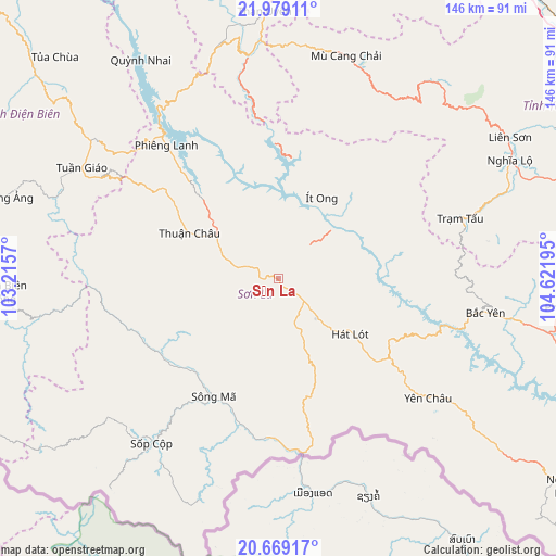
Sơn La GPS coordinates[2]
21° 19' 32.16" North, 103° 55' 7.752" East
| Map corner | latitude | longitude |
|---|---|---|
| Upper-left | 21.97911°, | 103.2157° |
| Center: | 21.3256°, | 103.91882° |
| Lower-right: | 20.66917°, | 104.62195° |
| Map W x H: | 145.7×145.7 km | = 90.5×90.5mi |
| max Lat: | 23.27841° ⇑17.1% North |
| Sơn La: | 21.3256° |
| min Lat: | ⇓82.9% South 8.65724° |
| min Long | Sơn La | max Long |
| 102.4579° | 103.91882° | 112.72541° |
| W 3.4%⇐ | ⇒96.6% E |
Elevation
Elevation of Sơn La is 608 m = 1995 ft, and this is 478.5 m = 1570 ft above average elevation for this country.
| Max E: |
1592 m = 5223 ft | 6.5% |
| Sơn La | 608 m 1995 ft | |
| Avg. | 129.5 m = 425 ft | |
Min E: |
-1 m = -3 ft | 93.5% |
See also: Vietnam elevation on elevation.city.
Geographical zone
Sơn La is located in North Torrid zone (between Equator and Tropic of Cancer). Distance of this Northern Tropic circle is 234.7 km =145.8 mi to North.| Distance of | km | miles | from Sơn La |
|---|---|---|---|
| North Pole | 7635.9 | 4744.7 | to North |
| Arctic Circle | 5030 | 3125.5 | to North |
| Tropic Cancer | 234.7 | 145.8 | to North |
| Equator | 2371.2 | 1473.4 | to South |


Nearby cities:
15 places around Sơn La: (largest is in red/bold)
• Bắc Yên
54 km =33.6 mi,  99°
99°
• Hát Lót
24.1 km =15 mi,  126°
126°
• Mù Cang Chải
61.1 km =38 mi,  16°
16°
• Mường Chiên
68.1 km =42.3 mi,  327°
327°
• Mường Ảng
75.2 km =46.7 mi,  286°
286°
• Phù Yên
75.5 km =46.9 mi, 95°
• Sông Mã
35.2 km =21.9 mi,  209°
209°
• Sơn Thịnh
74.8 km =46.5 mi,  69°
69°
• Than Uyên
70.5 km =43.8 mi,  356°
356°
• Thị Trấn Thuận Châu
26.8 km =16.7 mi,  297°
297°
• Thị Trấn Trạm Tấu
50.2 km =31.2 mi, 71°
• Thị Trấn Tuần Giáo
59.2 km =36.8 mi, 299°
• Yên Châu
50.4 km =31.3 mi, 128°
• Ít Ong
24.1 km =15 mi,  27°
27°
• Điện Biên Đông
72.5 km =45 mi,  267°
267°
Sources, notices
• [Note1] Compared only with cities in Vietnam existing in our database
• [Src1] Map data: © OpenStreetMap contributors (CC-BY-SA)
• [Src2] Other city data from geonames.org with taken over terms of usage.
• [Src3] Geographical zone / Annual Mean Temperature by Robert A. Rohde @ Wikipedia
