Thị Trấn Trạm Tấu geodata
Thị Trấn Trạm Tấu (Yên Bái) is a seat of a second-order administrative division; located in Vietnam in Asia/Ho_Chi_Minh (GMT+7) time zone. In our database, there are 94 cities with bigger population. Compared to other cities in Vietnam, 85.5% of cities are located further ↓South; 94.5% of cities are located further →East and 94.8% of cities have lower elevation than Thị Trấn Trạm Tấu. Note1


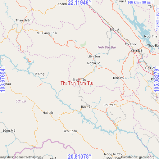
Thị Trấn Trạm Tấu GPS coordinates[2]
21° 27' 59.724" North, 104° 22' 46.776" East
| Map corner | latitude | longitude |
|---|---|---|
| Upper-left | 22.11946°, | 103.67654° |
| Center: | 21.46659°, | 104.37966° |
| Lower-right: | 20.81078°, | 105.08279° |
| Map W x H: | 145.5×145.5 km | = 90.4×90.4mi |
| max Lat: | 23.27841° ⇑14.5% North |
| Thị Trấn Trạm Tấu: | 21.46659° |
| min Lat: | ⇓85.5% South 8.65724° |
| min Long | Thị Trấn Tr | max Long |
| 102.4579° | 104.37966° | 112.72541° |
| W 5.5%⇐ | ⇒94.5% E |
Elevation
Elevation of Thị Trấn Trạm Tấu is 691 m = 2267 ft, and this is 561.5 m = 1842 ft above average elevation for this country.
| Max E: |
1592 m = 5223 ft | 5.2% |
| Thị Trấn Trạm Tấu | 691 m 2267 ft | |
| Avg. | 129.5 m = 425 ft | |
Min E: |
-1 m = -3 ft | 94.8% |
See also: Vietnam elevation on elevation.city.
Geographical zone
Thị Trấn Trạm Tấu is located in North Torrid zone (between Equator and Tropic of Cancer). Distance of this Northern Tropic circle is 219.1 km =136.1 mi to North.| Distance of | km | miles | from Thị Trấn Trạm Tấu |
|---|---|---|---|
| North Pole | 7620.2 | 4735 | to North |
| Arctic Circle | 5014.3 | 3115.7 | to North |
| Tropic Cancer | 219.1 | 136.1 | to North |
| Equator | 2386.9 | 1483.2 | to South |


Nearby cities:
15 places around Thị Trấn Trạm Tấu: (largest is in red/bold)
• Bắc Yên
25.1 km =15.6 mi,  167°
167°
• Cổ Phúc
56.4 km =35 mi,  55°
55°
• Hát Lót
41.2 km =25.6 mi,  223°
223°
• Hạ Hòa
65.6 km =40.8 mi,  80°
80°
• Mù Cang Chải
52.2 km =32.4 mi,  324°
324°
• Mộc Châu
72.8 km =45.2 mi,  159°
159°
• Phù Yên
35.5 km =22.1 mi,  129°
129°
• Sơn La
50.2 km =31.2 mi,  251°
251°
• Sơn Thịnh
24.7 km =15.3 mi, 64°
• Thị Trấn Khánh Yên
70.5 km =43.8 mi,  349°
349°
• Thị Trấn Thuận Châu
71.4 km =44.4 mi,  267°
267°
• Yên Bái
61.9 km =38.5 mi, 62°
• Yên Châu
47.5 km =29.5 mi,  189°
189°
• Yên Lập
71.4 km =44.4 mi,  100°
100°
• Ít Ong
36.9 km =22.9 mi,  278°
278°
Sources, notices
• [Note1] Compared only with cities in Vietnam existing in our database
• [Src1] Map data: © OpenStreetMap contributors (CC-BY-SA)
• [Src2] Other city data from geonames.org with taken over terms of usage.
• [Src3] Geographical zone / Annual Mean Temperature by Robert A. Rohde @ Wikipedia
