Tuyên Quang geodata
Tuyên Quang is a seat of a first-order administrative division; located in Vietnam in Asia/Ho_Chi_Minh (GMT+7) time zone. With population of 36,430 people, there are 70 cities with bigger population in this country. Compared to other cities in Vietnam, 88.9% of cities are located further ↓South; 85.6% of cities are located further →East and 65.4% of cities have lower elevation than Tuyên Quang. Note1


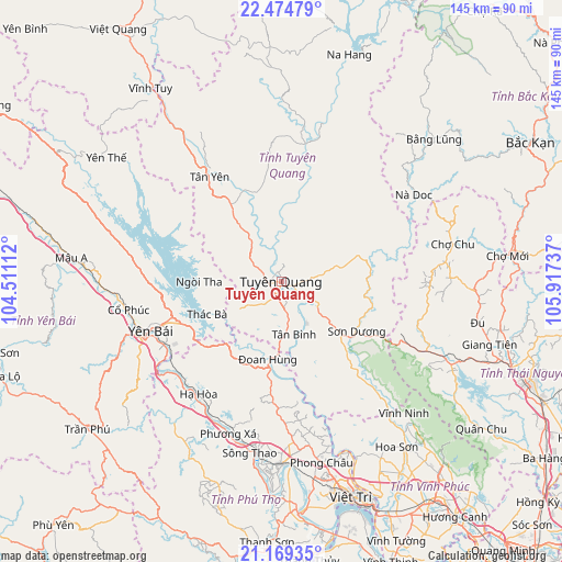
Tuyên Quang GPS coordinates[2]
21° 49' 24.816" North, 105° 12' 51.264" East
| Map corner | latitude | longitude |
|---|---|---|
| Upper-left | 22.47479°, | 104.51112° |
| Center: | 21.82356°, | 105.21424° |
| Lower-right: | 21.16935°, | 105.91737° |
| Map W x H: | 145.2×145.2 km | = 90.2×90.2mi |
| max Lat: | 23.27841° ⇑11.1% North |
| Tuyên Quang: | 21.82356° |
| min Lat: | ⇓88.9% South 8.65724° |
| min Long | Tuyên Quang | max Long |
| 102.4579° | 105.21424° | 112.72541° |
| W 14.4%⇐ | ⇒85.6% E |
Elevation
Elevation of Tuyên Quang is 35 m = 115 ft, and this is 94.5 m = 310 ft below average elevation for this country.
| Max E: |
1592 m = 5223 ft | 34.6% |
| Avg. | 129.5 m = 425 ft | |
| Tuyên Quang | 35 m = 115 ft | |
Min E: |
-1 m = -3 ft | 65.4% |
See also: Vietnam elevation on elevation.city.
Geographical zone
Tuyên Quang is located in North Torrid zone (between Equator and Tropic of Cancer). Distance of this Northern Tropic circle is 179.4 km =111.5 mi to North.| Distance of | km | miles | from Tuyên Quang |
|---|---|---|---|
| North Pole | 7580.5 | 4710.3 | to North |
| Arctic Circle | 4974.6 | 3091.1 | to North |
| Tropic Cancer | 179.4 | 111.5 | to North |
| Equator | 2426.6 | 1507.8 | to South |


Nearby cities:
15 places around Tuyên Quang: (largest is in red/bold)
• Chợ Chu
45.1 km =28 mi,  78°
78°
• Cổ Phúc
40.6 km =25.2 mi,  259°
259°
• Huyện Chiêm Hóa
36.2 km =22.5 mi,  9°
9°
• Hạ Hòa
36.1 km =22.4 mi,  216°
216°
• Lập Thạch
52.1 km =32.4 mi,  150°
150°
• Phong Châu
47.4 km =29.5 mi,  167°
167°
• Phú Thọ
47.1 km =29.3 mi,  178°
178°
• Sông Thao
45.5 km =28.3 mi,  190°
190°
• Sơn Dương
23.7 km =14.7 mi,  126°
126°
• Thanh Ba
36.9 km =22.9 mi, 191°
• Thị Trấn Tân Yên
32.7 km =20.3 mi,  325°
325°
• Thị Trấn Vĩnh Lộc
36.1 km =22.4 mi, 9°
• Yên Bái
33.2 km =20.6 mi,  250°
250°
• Đoan Hùng
22.6 km =14 mi, 187°
• Đu
51.4 km =31.9 mi,  100°
100°
Sources, notices
• [Note1] Compared only with cities in Vietnam existing in our database
• [Src1] Map data: © OpenStreetMap contributors (CC-BY-SA)
• [Src2] Other city data from geonames.org with taken over terms of usage.
• [Src3] Geographical zone / Annual Mean Temperature by Robert A. Rohde @ Wikipedia
