Chợ Chu geodata
Chợ Chu (Thái Nguyên) is a seat of a second-order administrative division; located in Vietnam in Asia/Ho_Chi_Minh (GMT+7) time zone. In our database, there are 94 cities with bigger population. Compared to other cities in Vietnam, 90.4% of cities are located further ↓South; 71.1% of cities are located further →East and 74.4% of cities have lower elevation than Chợ Chu. Note1


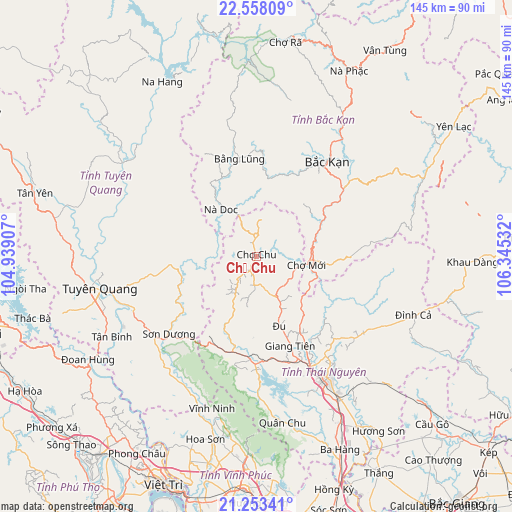
Chợ Chu GPS coordinates[2]
21° 54' 26.064" North, 105° 38' 31.884" East
| Map corner | latitude | longitude |
|---|---|---|
| Upper-left | 22.55809°, | 104.93907° |
| Center: | 21.90724°, | 105.64219° |
| Lower-right: | 21.25341°, | 106.34532° |
| Map W x H: | 145.1×145.1 km | = 90.2×90.2mi |
| max Lat: | 23.27841° ⇑9.6% North |
| Chợ Chu: | 21.90724° |
| min Lat: | ⇓90.4% South 8.65724° |
| min Long | Chợ Chu | max Long |
| 102.4579° | 105.64219° | 112.72541° |
| W 28.9%⇐ | ⇒71.1% E |
Elevation
Elevation of Chợ Chu is 92 m = 302 ft, and this is 37.5 m = 123 ft below average elevation for this country.
| Max E: |
1592 m = 5223 ft | 25.6% |
| Avg. | 129.5 m = 425 ft | |
| Chợ Chu | 92 m = 302 ft | |
Min E: |
-1 m = -3 ft | 74.4% |
See also: Vietnam elevation on elevation.city.
Geographical zone
Chợ Chu is located in North Torrid zone (between Equator and Tropic of Cancer). Distance of this Northern Tropic circle is 170.1 km =105.7 mi to North.| Distance of | km | miles | from Chợ Chu |
|---|---|---|---|
| North Pole | 7571.2 | 4704.5 | to North |
| Arctic Circle | 4965.3 | 3085.3 | to North |
| Tropic Cancer | 170.1 | 105.7 | to North |
| Equator | 2435.9 | 1513.6 | to South |


Nearby cities:
15 places around Chợ Chu: (largest is in red/bold)
• Bắc Kạn
33.2 km =20.6 mi,  36°
36°
• Bằng Lũng
28.3 km =17.6 mi,  350°
350°
• Chùa Hang
37.6 km =23.4 mi,  146°
146°
• Chợ Mới
13.7 km =8.5 mi,  100°
100°
• Huyện Chiêm Hóa
46.3 km =28.8 mi,  304°
304°
• Lập Thạch
57.8 km =35.9 mi,  198°
198°
• Phủ Thông
47.5 km =29.5 mi,  30°
30°
• Sơn Dương
34.3 km =21.3 mi,  227°
227°
• Thái Nguyên
40.8 km =25.4 mi, 148°
• Thị Trấn Na Hang
56 km =34.8 mi,  331°
331°
• Thị Trấn Vĩnh Lộc
46.3 km =28.8 mi, 304°
• Trai Ngau
57.2 km =35.5 mi,  182°
182°
• Tuyên Quang
45.1 km =28 mi,  258°
258°
• Đoan Hùng
56.9 km =35.4 mi,  236°
236°
• Đu
19.8 km =12.3 mi,  161°
161°
Sources, notices
• [Note1] Compared only with cities in Vietnam existing in our database
• [Src1] Map data: © OpenStreetMap contributors (CC-BY-SA)
• [Src2] Other city data from geonames.org with taken over terms of usage.
• [Src3] Geographical zone / Annual Mean Temperature by Robert A. Rohde @ Wikipedia
