Chí Thạnh geodata
Chí Thạnh (Phú Yên) is a seat of a second-order administrative division; located in Vietnam in Asia/Ho_Chi_Minh (GMT+7) time zone. In our database, there are 94 cities with bigger population. Compared to other cities in Vietnam, 63% of cities are located further ↑North; 99.2% of cities are located further ←West and 50.4% of cities have higher elevation than Chí Thạnh. Note1


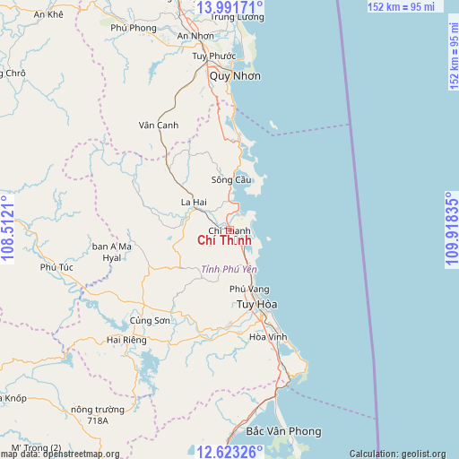
Chí Thạnh GPS coordinates[2]
13° 18' 30.42" North, 109° 12' 54.792" East
| Map corner | latitude | longitude |
|---|---|---|
| Upper-left | 13.99171°, | 108.5121° |
| Center: | 13.30845°, | 109.21522° |
| Lower-right: | 12.62326°, | 109.91835° |
| Map W x H: | 152.2×152.2 km | = 94.6×94.6mi |
| max Lat: | 23.27841° ⇑63% North |
| Chí Thạnh: | 13.30845° |
| min Lat: | ⇓37% South 8.65724° |
| min Long | Chí Thạnh | max Long |
| 102.4579° | 109.21522° | 112.72541° |
| W 99.2%⇐ | ⇒0.8% E |
Elevation
Elevation of Chí Thạnh is 14 m = 46 ft, and this is 115.5 m = 379 ft below average elevation for this country.
| Max E: |
1592 m = 5223 ft | 50.4% |
| Avg. | 129.5 m = 425 ft | |
| Chí Thạnh | 14 m = 46 ft | |
Min E: |
-1 m = -3 ft | 49.6% |
See also: Vietnam elevation on elevation.city.
Geographical zone
Chí Thạnh is located in North Torrid zone (between Equator and Tropic of Cancer). Distance of this Northern Tropic circle is 1126.2 km =699.8 mi to North.| Distance of | km | miles | from Chí Thạnh |
|---|---|---|---|
| North Pole | 8527.3 | 5298.6 | to North |
| Arctic Circle | 5921.4 | 3679.4 | to North |
| Tropic Cancer | 1126.2 | 699.8 | to North |
| Equator | 1479.8 | 919.5 | to South |


Nearby cities:
15 places around Chí Thạnh: (largest is in red/bold)
• A Yun Pa
85 km =52.8 mi,  276°
276°
• An Nhơn
65.2 km =40.5 mi,  349°
349°
• Củng Sơn
38.5 km =23.9 mi,  221°
221°
• Hai Riêng
50.3 km =31.3 mi, 223°
• La Hai
13.9 km =8.6 mi,  303°
303°
• M’Đrăk
80.8 km =50.2 mi, 219°
• Phù Cát
79.1 km =49.2 mi, 347°
• Phú Phong
74.1 km =46 mi,  334°
334°
• Phú Túc
58.1 km =36.1 mi,  257°
257°
• Qui Nhon
52 km =32.3 mi,  1°
1°
• Sông Cầu
16.4 km =10.2 mi, 3°
• Tuy Hòa
26.3 km =16.3 mi,  154°
154°
• Tuy Phước
57.9 km =36 mi, 354°
• Vân Canh
41.8 km =26 mi, 325°
• Vạn Giã
68.5 km =42.6 mi,  179°
179°
Sources, notices
• [Note1] Compared only with cities in Vietnam existing in our database
• [Src1] Map data: © OpenStreetMap contributors (CC-BY-SA)
• [Src2] Other city data from geonames.org with taken over terms of usage.
• [Src3] Geographical zone / Annual Mean Temperature by Robert A. Rohde @ Wikipedia
